1930s Maps of South Padre Island, Texas
Explore 3 historic maps of South Padre Island from the 1930s. These maps offer a rare glimpse into what life looked like during the 1930s — showing old roads, neighborhoods, homes, and landmarks that have changed or disappeared over time.
Whether you're researching your family's past, planning a metal detecting trip, or studying how South Padre Island's landscape evolved across the 1930s, these high-resolution maps are a powerful tool for exploring the history of this region.
- Focus on a specific era: All maps on this page are from the 1930s, giving you a focused view of this time period.
- See what’s changed: Compare century-old streets, trails, and buildings to today's modern landscape using overlays and satellite layers.
- Research with precision: Use these maps for genealogy, historical research, land use analysis, or educational projects.
- View, download, or print: Maps are fully viewable online in high resolution, and can be downloaded or printed for your own records.
Start exploring South Padre Island's history through authentic maps from the 1930s. This is your window into the past.
South Padre Island, TX maps
(3)- 1930 Map of Padre Island No. 1
 1930 Padre Island No. 11930 Print · USGSThe South Texas coast in 1930 appears as a quiet landscape of shifting sands and tidal reaches. Researchers can trace the early topography of Padre Island, the vast Laguna Madre shoreline, and the curious site of an (Abandoned Hotel).
 - 1934 Map of Port Isabel
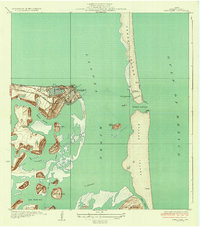 1934 Port Isabel1934 Print · USGSCoastal Cameron County in the early thirties reveals a burgeoning maritime hub at the edge of the Laguna Madre. Trace the early infrastructure of Port Isabel, from the Rio Grande Valley RR terminus to the Plank Road on Padre Island.2 unique versions available
 - 1935 Map of Padre Island No 1
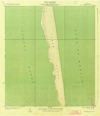 1935 Padre Island No 11935 Print · USGSThe South Texas barrier coast appears in its pre-development state during the mid-1930s, showing the wild stretch of Padre Island. Researchers can trace the original shoreline and the vast waters of the Laguna Madre and the Gulf of Mexico.2 unique versions available
End of results
Showing maps 1-3 of 3
Top cities near South Padre Island
- Brownsville historical maps
- Port Isabel historical maps
- Laguna Vista historical maps
- Bayview historical maps
Frequently asked questions
- What are the different types of historical maps available for South Padre Island?
- What is the oldest map of South Padre Island?
- Where can I purchase historical maps of South Padre Island for my home or office?
- Where can I download high-res historical maps of South Padre Island?
- Are there historical topographic maps available for South Padre Island?
- Is there historical aerial imagery available for South Padre Island?
- Where are historical maps of South Padre Island sourced from?