1960s Maps of Panhandle, Texas
Explore 2 historic maps of Panhandle from the 1960s. These maps offer a rare glimpse into what life looked like during the 1960s — showing old roads, neighborhoods, homes, and landmarks that have changed or disappeared over time.
Whether you're researching your family's past, planning a metal detecting trip, or studying how Panhandle's landscape evolved across the 1960s, these high-resolution maps are a powerful tool for exploring the history of this region.
- Focus on a specific era: All maps on this page are from the 1960s, giving you a focused view of this time period.
- See what’s changed: Compare century-old streets, trails, and buildings to today's modern landscape using overlays and satellite layers.
- Research with precision: Use these maps for genealogy, historical research, land use analysis, or educational projects.
- View, download, or print: Maps are fully viewable online in high resolution, and can be downloaded or printed for your own records.
Start exploring Panhandle's history through authentic maps from the 1960s. This is your window into the past.
Panhandle, TX maps
(2)- 1966 Map of Panhandle West, 1967 Print
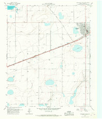 1966 Panhandle West1967 Print · USGSThe High Plains of Carson County come into focus in the mid-1960s, centered on the rail hub of Panhandle. Genealogists and historians can trace the early township at Lee, locate the landmark Bois d'Arc Tree, and explore the infrastructure of the Military Reservation.
 - 1966 Map of Panhandle East, 1967 Print
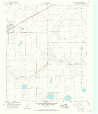 1966 Panhandle East1967 Print · USGSCarson County's high plains economy is on full display in the mid-1960s as the railroad and agricultural industry converge. Trace the rail siding at Panhandle past the Grain Elevator or locate rural landmarks like Heaston and the local Cem.
End of results
Showing maps 1-2 of 2
Top cities near Panhandle
Frequently asked questions
- What are the different types of historical maps available for Panhandle?
- What is the oldest map of Panhandle?
- Where can I purchase historical maps of Panhandle for my home or office?
- Where can I download high-res historical maps of Panhandle?
- Are there historical topographic maps available for Panhandle?
- Is there historical aerial imagery available for Panhandle?
- Where are historical maps of Panhandle sourced from?