1950s Maps of Cass County, Texas
Explore 9 historic maps of Cass County from the 1950s. These maps offer a rare glimpse into what life looked like during the 1950s — showing old roads, neighborhoods, homes, and landmarks that have changed or disappeared over time.
Whether you're researching your family's past, planning a metal detecting trip, or studying how Cass County's landscape evolved across the 1950s, these high-resolution maps are a powerful tool for exploring the history of this region.
- Focus on a specific era: All maps on this page are from the 1950s, giving you a focused view of this time period.
- See what’s changed: Compare century-old streets, trails, and buildings to today's modern landscape using overlays and satellite layers.
- Research with precision: Use these maps for genealogy, historical research, land use analysis, or educational projects.
- View, download, or print: Maps are fully viewable online in high resolution, and can be downloaded or printed for your own records.
Start exploring Cass County's history through authentic maps from the 1950s. This is your window into the past.
Cass County, TX maps
(9)- 1953 Map of Texarkana, 1964 Print
 1953 Texarkana1964 Print · USGSThe Texas-Arkansas borderlands are captured here in the mid-fifties, during a decade of massive military and hydraulic engineering projects. Genealogists and researchers can locate family landmarks like Old Boston Cem, Siloam Ch, and the vast Red River Arsenal.4 unique versions available
 - 1954 Map of Domino, 1955 Print
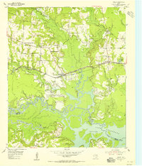
 1954 Domino1955 Print · USGSCrossing the Texas and Arkansas border in the mid-fifties, this area shows a landscape defined by the winding Sulphur River and active gravel mining. Genealogists can locate rural landmarks like Buchanan Cem, Bright Star Ch, and the settlement of Domino.5 unique versions available
 - 1954 Map of Lake Texarkana, 1955 Print
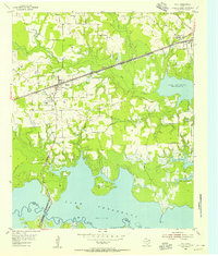
 1954 Lake Texarkana1955 Print · USGSNortheast Texas is captured here in the mid-fifties during the transformation of the Sulphur River valley. Genealogists and historians can locate rural landmarks like Opossum Trot Church, the Holloway Cem, and the crossing at McCartney Bridge.6 unique versions available
 - 1954 Map of Texarkana, 1960 Print
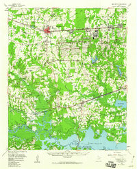
 1954 Texarkana1960 Print · USGSTexarkana and its surrounding borderlands are captured at a mid-century peak of industrial and suburban growth. Genealogists and historians can trace the foundations of Wake Village, locate the Red River Arsenal, and find rural landmarks like Hampton Chapel and Red Springs Cem.2 unique versions available
 - 1955 Map of Corley
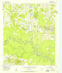
 1955 Corley1955 Print · USGSBowie County rural life in the mid-fifties is captured here as a new road network begins to take shape. Researchers can locate family landmarks such as Old Union Cem, Mount Obie Ch, and the small settlement of Carbondale.3 unique versions available
 - 1955 Map of Maud
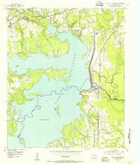
 1955 Maud1955 Print · USGSBowie County's rail-and-water landscape comes alive in the mid-fifties, centered on the growing town of Maud. Genealogists can trace family sites at Harris Cem and Oak Ridge Ch or explore the early shores of Lake Texarkana.3 unique versions available
 - 1955 Map of New Boston, 1960 Print
 1955 New Boston1960 Print · USGSBowie County in the mid-1950s is defined by the massive footprint of the Red River Arsenal and the burgeoning waters of Lake Texarkana. Researchers can trace the migration of local centers from Old Boston to New Boston while locating family landmarks like Red Bayou Cem and Magnolia Ch.
 - 1956 Map of Texarkana
 1956 Texarkana1956 Print · USGSThe Ark-La-Tex borderlands come alive in the mid-fifties, showing the transition from a rail-dependent rural economy to a post-war industrial landscape. Researchers can trace the massive Red River Ordnance Depot and find towns like Talco, Bogata, and Naples.
 - 1956 Map of Tyler
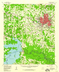
 1956 Tyler1956 Print · USGSEast Texas was a powerhouse of oil production and rail transport during the mid-fifties, centered on the sprawling East Texas Oil Field. Researchers can trace the heritage of industrial hubs like Kilgore, military sites such as the Longhorn Ordnance Works, and many rural landmarks like Mount Enterprise.5 unique versions available
End of results
Showing maps 1-9 of 9
Top cities of Cass County
- Atlanta historical maps
- Linden historical maps
- Hughes Springs historical maps
- Queen City historical maps
- Avinger historical maps
- Bloomburg historical maps
See more
Frequently asked questions
- What are the different types of historical maps available for Cass County?
- What is the oldest map of Cass County?
- Where can I purchase historical maps of Cass County for my home or office?
- Where can I download high-res historical maps of Cass County?
- Are there historical topographic maps available for Cass County?
- Is there historical aerial imagery available for Cass County?
- Where are historical maps of Cass County sourced from?