1960s Maps of Cass County, Texas
Explore 20 historic maps of Cass County from the 1960s. These maps offer a rare glimpse into what life looked like during the 1960s — showing old roads, neighborhoods, homes, and landmarks that have changed or disappeared over time.
Whether you're researching your family's past, planning a metal detecting trip, or studying how Cass County's landscape evolved across the 1960s, these high-resolution maps are a powerful tool for exploring the history of this region.
- Focus on a specific era: All maps on this page are from the 1960s, giving you a focused view of this time period.
- See what’s changed: Compare century-old streets, trails, and buildings to today's modern landscape using overlays and satellite layers.
- Research with precision: Use these maps for genealogy, historical research, land use analysis, or educational projects.
- View, download, or print: Maps are fully viewable online in high resolution, and can be downloaded or printed for your own records.
Start exploring Cass County's history through authentic maps from the 1960s. This is your window into the past.
Cass County, TX maps
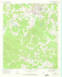
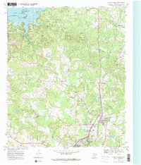
(20)- 1961 Map of Cunningham Creek, 1963 Print
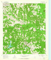
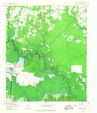
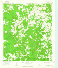 1961 Cunningham Creek1963 Print · USGSCass County, Texas, is documented here in the early 1960s, showing a landscape of bayous and small rural settlements. Genealogists can locate family landmarks like the Bear Creek Cem and Caves Spring Ch or trace the winding course of Black Cypress Creek.
 - 1962 Map of McLeod, 1963 Print
 1962 McLeod1963 Print · USGSThe Texas-Louisiana borderlands come into focus in the early sixties, showing a landscape defined by petroleum production and rural rail lines. Researchers can trace family sites and industry via the Kansas City Southern, Josey Cem, and the Refinery near North Rodessa.2 unique versions available
 - 1962 Map of Lanier, 1963 Print
 1962 Lanier1963 Print · USGSEast Texas at the start of the sixties reveals a landscape shaped by oil, iron ore, and rural settlement. Genealogists can trace family landmarks like Salem Cem and Zion Hill Cem alongside industrial features like the Strip Mines and the Texas and Pacific railroad.
 - 1962 Map of Kildare, 1963 Print
 1962 Kildare1963 Print · USGSEastern Texas oil and rail culture meet in the early sixties near the Marion County line. Genealogists and industrial historians can trace the Texas and Pacific rail line through Kildare and locate the Kildare Oil Field and Terrell Cem.2 unique versions available
 - 1962 Map of Avinger, 1964 Print
 1962 Avinger1964 Print · USGSEast Texas rail and timber lands are frozen in time during the early sixties, centered on the junction of Avinger and Hughes Springs. Genealogists and local historians can trace rural roots at Mt Moriah Ch, Traylor Sch, and family landmarks like Donaldson Mountain.2 unique versions available
 - 1962 Map of Lone Star, 1964 Print
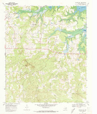
 1962 Lone Star1964 Print · USGSMorris County in the early sixties was a hub of East Texas industry and rural life, from the growing town of Lone Star to the heavy iron works. Researchers can trace the massive Steel Plant, local landmarks like Hospital in the Pines, and old family burial grounds including South Union Cem.2 unique versions available
 - 1964 Map of Daingerfield, 1967 Print
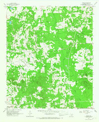
 1964 Daingerfield1967 Print · USGSMorris County was a hub of rail activity and iron-ore mining in the mid-sixties, centered on the growing town of Daingerfield. Genealogists and historians can trace the foundations of local life at Daingerfield State Park, the Black Mountain Mine, and several rural landmarks like Bradfield Ch.2 unique versions available
 - 1965 Map of Marietta, 1967 Print
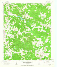
 1965 Marietta1967 Print · USGSThe Cass County countryside in the mid-sixties is captured here, showing the rural communities between the Sulphur River and Marietta. Genealogists can trace family landmarks like Bethlehem Cem, Bryans Mill, and the St Louis Southwestern rail line.2 unique versions available
 - 1965 Map of Dalby Springs, 1967 Print
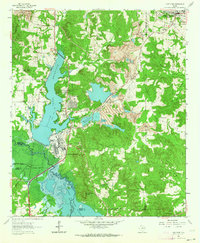
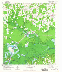
 1965 Dalby Springs1967 Print · USGSBowie County and the Sulphur River bottomlands are captured here in the mid-1960s during a period of significant hydraulic change. Genealogists and local historians can trace family sites like Roberts Cem, the village of Dalby, and the rising shoreline of Lake Texarkana.2 unique versions available
 - 1965 Map of Sardis, 1967 Print
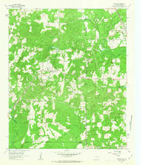
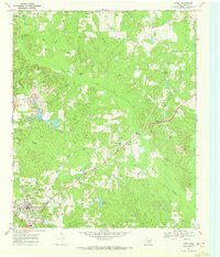
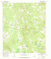
 1965 Sardis1967 Print · USGSCass County, Texas, is captured here in the mid-1960s as a region of timbered creeks and small rural settlements. Researchers can locate family landmarks like the Crossroads Community Center, Mt Olive Ch, and the Old Union Hill Cem.
 - 1965 Map of Bassett, 1967 Print
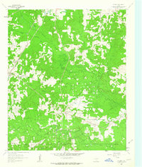
 1965 Bassett1967 Print · USGSBowie and Cass counties are shown here in the mid-sixties during the development of the Sulphur River reservoir system. Genealogists and local historians can trace family-named sites like Powell Cem, the settlement at Bassett, and the Ward Creek Ch.2 unique versions available
 - 1965 Map of Naples, 1967 Print
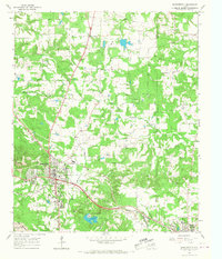
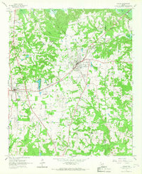 1965 Naples1967 Print · USGSNortheast Texas in the mid-sixties reveals a landscape defined by the railroad and established country communities. Genealogists and historians can trace the foundations of Naples and Omaha, locating local landmarks like Pewitt Sch and Spring Hill Cem.2 unique versions available
 - 1969 Map of Atlanta South
 1969 Atlanta South1969 Print · USGSEast Texas at the close of the 1960s reveals a landscape of timber, rail, and rural crossroads south of Atlanta. Genealogists and historians can locate family landmarks like Laws Chapel Cem or trace the Texas and Pacific line through Bivins.
 - 1969 Map of Linden, 1972 Print
 1969 Linden1972 Print · USGSLinden and its surrounding Cass County countryside are captured here in the late sixties, showing a rural landscape transitioning toward modern infrastructure. Local historians can trace old community hubs like New Colony, family burial sites at Echols Cem, and the layout of the Rodeo Ground.2 unique versions available
 - 1969 Map of Douglassville, 1972 Print
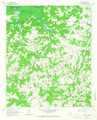
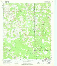
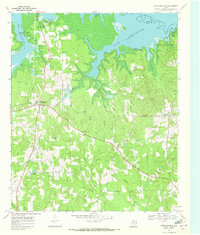 1969 Douglassville1972 Print · USGSEast Texas creek bottoms and the shoreline of Lake Texarkana define this corner of Cass County in the late sixties. Researchers can locate community anchors like St John Ch, trace the path of the Sulphur River, and find family-named landmarks like Rutland Cem.
 - 1969 Map of Bloomburg, 1972 Print
 1969 Bloomburg1972 Print · USGSThe Texas-Arkansas borderlands in the late sixties are captured here as a landscape of timbered creek bottoms and small railroad towns. Genealogists can locate specific rural landmarks like Macedonia Cem, Golden Gate Ch, and the community of Bloomburg.
 - 1969 Map of Atlanta North, 1972 Print
 1969 Atlanta North1972 Print · USGSNorthern Cass County during the late sixties shows a mix of growing towns and rural tradition. Genealogists can trace family names at Forest Home Cem or locate historic congregations at Shady Grove Ch and Courtland Ch.2 unique versions available
 - 1969 Map of Bryans Mill, 1973 Print
 1969 Bryans Mill1973 Print · USGSNortheastern Texas during the late sixties shows a mix of traditional timberland life and emerging energy production. Researchers can trace family roots through sites like Bryans Mill, the Cusseta settlement, and many rural landmarks like Union Chapel or Pleasant Hill Cem.2 unique versions available
 - 1969 Map of Carterville, 1973 Print
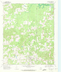
 1969 Carterville1973 Print · USGSCass County in the late sixties reveals a landscape of winding creek bottoms and quiet crossroads communities. Genealogists can trace family roots at Bethel-Cass Ch and Boon Cem, or locate the Old Railroad Grade near Carterville.
 - 1969 Map of Ravanna, 1973 Print
 1969 Ravanna1973 Print · USGSThe tri-state border where Texas, Arkansas, and Louisiana meet comes alive in the late sixties, centered on the Rodessa Oil and Gas Field. Genealogists can trace family names through Beach Creek Cem and communities like Three States or Loutexark.2 unique versions available
End of results
Showing maps 1-20 of 20
Top cities of Cass County
- Atlanta historical maps
- Linden historical maps
- Hughes Springs historical maps
- Queen City historical maps
- Avinger historical maps
- Bloomburg historical maps
See more
Frequently asked questions
- What are the different types of historical maps available for Cass County?
- What is the oldest map of Cass County?
- Where can I purchase historical maps of Cass County for my home or office?
- Where can I download high-res historical maps of Cass County?
- Are there historical topographic maps available for Cass County?
- Is there historical aerial imagery available for Cass County?
- Where are historical maps of Cass County sourced from?