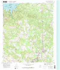
1969 Map of Atlanta North
USGS Topo · Published 1972About this map
Atlanta State Park borders the rising waters of Lake Texarkana in this 1960s study of Cass County, Texas. The landscape is defined by the Sulphur River drainage system and the north-south corridor of the Texas and Pacific railroad, which anchors the settlements of Queen City and Atlanta. The map reveals a deeply established rural social fabric, with numerous small country churches and cemeteries such as Forest Home Ch, Mt Zion Ch, and Piney Grove Ch scattered among the tributary networks of Black Bayou and Hickory Creek. Outside the primary towns, local activity is focused around features like the Rodeo Ground near Springdale and several active Gravel Pits, illustrating the era's balance between agriculture, local recreation, and the burgeoning infrastructure around the reservoir.
Find a feature on this map
31 named features on this map. Tap any name to fly to it.
Don’t see what you’re looking for? This feature index may not catch every label — zoom into the map to look around manually.
Map Details
Editions of this 1969 Atlanta North Map
2 editions found
Other maps of this area

1907 · Atlanta
USGS Topo · 1:62,500

1909 · New Boston
USGS Topo · 1:62,500

1909 · Texarkana
USGS Topo · 1:62,500

1910 · Linden
USGS Topo · 1:62,500

1910 · Atlanta
USGS Topo · 1:62,500

1953 · Texarkana
USGS Topo · 1:250,000

1954 · Domino
USGS Topo · 1:24,000

1954 · Lake Texarkana
USGS Topo · 1:24,000
1954 · Texarkana
USGS Topo · 1:62,500

1955 · Maud
USGS Topo · 1:24,000