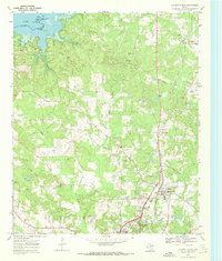
1969 Map of Atlanta North
USGS Topo · Published 1972About this map
Lake Texarkana dominates the northwest corner of this Cass County landscape, where the Sulphur River feeds into the reservoir at the Bowie Co Cass Co line. The terrain is defined by a dense network of drainages including Hickory Hill Creek and Black Bayou, which carve through the wooded hills east of Hickory Hill. Civil life in the late 1960s is centered on the growing corridor between Atlanta and Queen City, where the Texas and Pacific railroad parallels the main highway routes.
Find a feature on this map
35 named features on this map. Tap any name to fly to it.
Don’t see what you’re looking for? This feature index may not catch every label — zoom into the map to look around manually.
Map Details
Editions of this 1969 Atlanta North Map
2 editions found
Other maps of this area

1907 · Atlanta
USGS Topo · 1:62,500

1909 · New Boston
USGS Topo · 1:62,500

1909 · Texarkana
USGS Topo · 1:62,500

1910 · Linden
USGS Topo · 1:62,500

1910 · Atlanta
USGS Topo · 1:62,500

1953 · Texarkana
USGS Topo · 1:250,000

1954 · Domino
USGS Topo · 1:24,000

1954 · Lake Texarkana
USGS Topo · 1:24,000
1954 · Texarkana
USGS Topo · 1:62,500

1955 · Maud
USGS Topo · 1:24,000