Old Maps of Winnie, Texas for Metal Detecting
Plan your next treasure hunt with 8 historic maps of Winnie. Find old homesites, ghost towns, trails, and gathering spots that may be lost to time — perfect for identifying promising metal detecting locations.
- Locate forgotten sites: Uncover places like long-lost settlements, abandoned rail lines, or gathering spots.
- Plan better hunts: Use map overlays combined with LiDAR or satellite views to narrow in on historically rich areas.
- Made for detectorists: Thousands of hobbyists use these maps to discover relics, coins, and hidden history.
Use these historic maps to boost your research and find new opportunities beneath the surface of Winnie.
Winnie, TX maps
(8)- 1943 Map of Stowell, 1956 Print
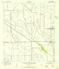 1943 Stowell1956 Print · USGSCoastal Texas prairie life during the mid-forties centered on the growing rail-side communities of Winnie and Stowell. Genealogists and historians can trace the early irrigation networks of the Lone Star Canal and locate local landmarks like School No 2 and Oil Wells.
 - 1950 Map of Houston, 1953 Print
 1950 Houston1953 Print · USGSCoastal Texas in the early fifties reveals a landscape of massive civil engineering and industrial transit. Genealogists and researchers can trace the growth of the Houston suburbs and the maritime infrastructure of Galveston Bay, including the Gulf Freeway and the Texas City Dike.
 - 1956 Map of Houston, 1963 Print
 1956 Houston1963 Print · USGSSoutheast Texas in the mid-fifties is captured here as a powerhouse of oil and maritime trade. Genealogists and historians can trace the foundations of Houston and its ports, alongside landmarks like the Rice Institute and the Spindletop Oil Field.2 unique versions available
 - 1962 Map of Stowell, 1964 Print
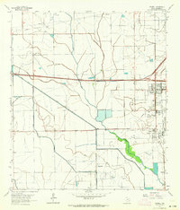 1962 Stowell1964 Print · USGSThe coastal prairies of Chambers County in the early sixties reveal a landscape shaped by petroleum and irrigation. Genealogists and historians can trace family-named sites near Winnie and Stowell, alongside the Sea Breeze Oil Field and Fairview Cem.3 unique versions available
 - 1975 Map of Houston, 1977 Print
 1975 Houston1977 Print · USGSThe Texas Gulf Coast in the mid-seventies shows a sprawling Houston metropolis linked to the sea by the massive Houston Ship Channel. Researchers can trace the mid-century industrial landscape from the Astrodome to the Lyndon B. Johnson Space Center.2 unique versions available
 - 1983 Map of Anahuac
 1983 Anahuac1983 Print · USGSThe Upper Texas Coast and its energy-driven landscape are detailed here in the early eighties. Genealogists and historians can trace coastal settlements like Anahuac and Winnie alongside the storied Spindletop Oil Field and the Anahuac National Wildlife Refuge.2 unique versions available
 - 1993 Map of Stowell, 1994 Print
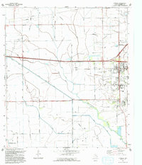 1993 Stowell1994 Print · USGSChambers County coastal prairie life thrives in the early nineties near the junction of agricultural canals and oil fields. Genealogists and locals can trace the Winnie and Stowell townsites, the Fairview Cem, and schools like E Chambers High Sch.
 - 2025 Map of Stowell, 2025 Print
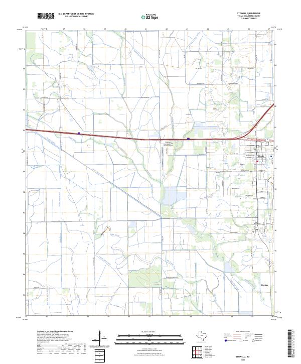 2025 Stowell2025 Print · USGSThe coastal plains of Chambers County come alive in this recent survey of the Texas gulf coast interior. Genealogists and researchers can trace local family landmarks such as Fairview Cem and the rural roads surrounding Winnie and Stowell.
End of results
Showing maps 1-8 of 8
Top cities near Winnie
Frequently asked questions
- What are the different types of historical maps available for Winnie?
- What is the oldest map of Winnie?
- Where can I purchase historical maps of Winnie for my home or office?
- Where can I download high-res historical maps of Winnie?
- Are there historical topographic maps available for Winnie?
- Is there historical aerial imagery available for Winnie?
- Where are historical maps of Winnie sourced from?