1960s Maps of Childress, Texas
Explore 2 historic maps of Childress from the 1960s. These maps offer a rare glimpse into what life looked like during the 1960s — showing old roads, neighborhoods, homes, and landmarks that have changed or disappeared over time.
Whether you're researching your family's past, planning a metal detecting trip, or studying how Childress's landscape evolved across the 1960s, these high-resolution maps are a powerful tool for exploring the history of this region.
- Focus on a specific era: All maps on this page are from the 1960s, giving you a focused view of this time period.
- See what’s changed: Compare century-old streets, trails, and buildings to today's modern landscape using overlays and satellite layers.
- Research with precision: Use these maps for genealogy, historical research, land use analysis, or educational projects.
- View, download, or print: Maps are fully viewable online in high resolution, and can be downloaded or printed for your own records.
Start exploring Childress's history through authentic maps from the 1960s. This is your window into the past.
Childress, TX maps
(2)- 1967 Map of Childress, 1969 Print
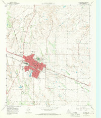 1967 Childress1969 Print · USGSChildress flourished as a railroad and highway crossroads in the Texas Panhandle during the late sixties. Genealogists and historians can locate specific neighborhood landmarks like East Ward Sch, the local Cemetery, and the Fort Worth and Denver line.2 unique versions available
 - 1967 Map of Carey, 1970 Print
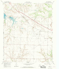 1967 Carey1970 Print · USGSPanhandle ranching and rail travel intersect in Childress County during the late sixties. Genealogists and local historians can trace the Carey settlement, the Carey Cem, and mid-century landmarks like the Drive-in Theater and Baylor Lake.2 unique versions available
End of results
Showing maps 1-2 of 2
Top cities near Childress
Frequently asked questions
- What are the different types of historical maps available for Childress?
- What is the oldest map of Childress?
- Where can I purchase historical maps of Childress for my home or office?
- Where can I download high-res historical maps of Childress?
- Are there historical topographic maps available for Childress?
- Is there historical aerial imagery available for Childress?
- Where are historical maps of Childress sourced from?