1980s Maps of Clay County, Texas
Explore 17 historic maps of Clay County from the 1980s. These maps offer a rare glimpse into what life looked like during the 1980s — showing old roads, neighborhoods, homes, and landmarks that have changed or disappeared over time.
Whether you're researching your family's past, planning a metal detecting trip, or studying how Clay County's landscape evolved across the 1980s, these high-resolution maps are a powerful tool for exploring the history of this region.
- Focus on a specific era: All maps on this page are from the 1980s, giving you a focused view of this time period.
- See what’s changed: Compare century-old streets, trails, and buildings to today's modern landscape using overlays and satellite layers.
- Research with precision: Use these maps for genealogy, historical research, land use analysis, or educational projects.
- View, download, or print: Maps are fully viewable online in high resolution, and can be downloaded or printed for your own records.
Start exploring Clay County's history through authentic maps from the 1980s. This is your window into the past.
Clay County, TX maps
(17)- 1984 Map of Hooper, 1985 Print
 1984 Hooper1985 Print · USGSThe Oklahoma-Texas borderlands come to life in this mid-eighties survey of the river country south of Waurika. Genealogists and local historians can trace the rural landscape around Hooper and Hastings, including the Hastings Cemetery and Pleasant Ridge Community Ctr.
 - 1984 Map of Irving, 1985 Print
 1984 Irving1985 Print · USGSThe Red River valley along the Oklahoma-Texas border is captured here in the early eighties as it flows through Jefferson County. Genealogists and local historians can trace the rural communities of Irving and Keele or explore the terrain of Bour Land and Patterson.
 - 1984 Map of Petrolia, 1985 Print
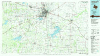
 1984 Petrolia1985 Print · USGSNorthern Texas at the dawn of the 1980s reveals a landscape defined by the winding Red River and the industrial footprint of the petroleum industry. Researchers can trace the Old Railroad Grade connecting Petrolia to Byers and locate the Riverside Cemetery near the river banks.
 - 1984 Map of Henrietta, 1985 Print
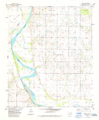
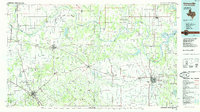
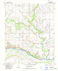
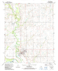
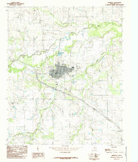 1984 Henrietta1985 Print · USGSHenrietta and the Clay County countryside are captured here in the mid-eighties as the community centered itself around the Little Wichita River. Researchers can trace the Old Railroad Grade, locate the Riverland Cemetery, and explore the layout of Dickworsham.
 - 1984 Map of Hurnville, 1985 Print
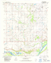
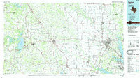
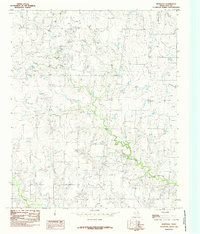 1984 Hurnville1985 Print · USGSClay County in the mid-eighties was a landscape of winding creek beds and active petroleum production. Genealogists and researchers can trace the rural layout of Hurnville, locate a local Cem, and study the extent of the northern Oil Field.
 - 1984 Map of Dickworsham, 1985 Print
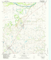
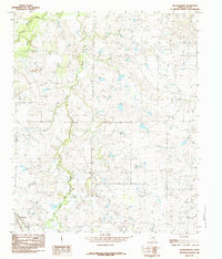 1984 Dickworsham1985 Print · USGSClay County ranch land in the mid-1980s is defined by the convergence of the Little Wichita River and its various forks. Genealogists and historians can trace the Old Railroad Grade or locate the site of Dickworsham and Corral Spring.
 - 1984 Map of Waurika West, 1985 Print
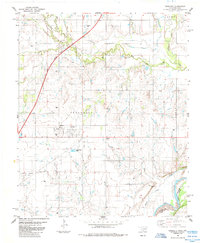
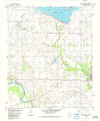 1984 Waurika West1985 Print · USGSJefferson County was undergoing significant water and transit changes in the mid-1980s as Waurika Lake took its modern shape. Researchers can trace the Old Railroad Grade and find local landmarks like Moneka Park and the original grid of Hastings.
 - 1985 Map of Graham
 1985 Graham1985 Print · USGSNorth Texas in the mid-eighties shows a landscape of growing reservoirs and historic cattle country. Genealogists and historians can trace the foundations of Young County through the Belknap Mountains, Barton Chapel, and the grounds of Fort Richardson State Park.2 unique versions available
 - 1985 Map of Gainesville
 1985 Gainesville1985 Print · USGSThe Red River valley in the mid-1980s reveals a landscape defined by the petroleum industry and a complex rail network. Researchers can trace the legacy of regional energy at the Bowers Field or locate community roots near Spanish Fort and Lakeview Cemetery.
 - 1985 Map of Randlett
 1985 Randlett1985 Print · USGSRandlett and the surrounding Cotton County plains are captured here in the mid-1980s as the regional petroleum and ranching landscape matured. Genealogists and local historians can locate Randlett Cem, trace the Southwest Randlett Oil Field, and see the footprint of Big Pasture High Sch.
 - 1985 Map of Denton
 1985 Denton1985 Print · USGSNorth Texas in the mid-eighties shows a region of growing towns and established rail lines. Trace family roots and local history through Wizard Wells, the old Oaklawn Cem, and the tracks of the Burlington Northern.
 - 1985 Map of Wichita Falls
 1985 Wichita Falls1985 Print · USGSWichita Falls and the surrounding North Texas oil patches are captured here during a period of established energy production and military importance. Genealogists and historians can trace family-named sites and regional hubs like Sheppard Air Force Base, Electra, and Lake Arrowhead State Park.2 unique versions available
 - 1985 Map of Taylor
 1985 Taylor1985 Print · USGSThe Oklahoma-Texas borderlands along the Red River are captured here in the mid-eighties during a period of active oil exploration. Researchers can trace the petroleum infrastructure of the West Cache Creek Oil Field and locate the small settlement of Taylor.
 - 1985 Map of Riverland Cemetery
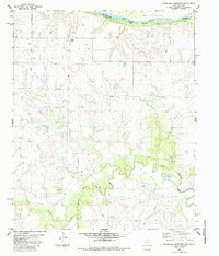 1985 Riverland Cemetery1985 Print · USGSThe Red River border between Texas and Oklahoma comes into focus in the mid-eighties, showing the rural Clay County landscape. Researchers can locate the Riverland Cemetery, the small community of Cube, and the winding Little Wichita River.
 - 1985 Map of Burkburnett, 1986 Print
 1985 Burkburnett1986 Print · USGSThe Red River valley and North Texas oil fields are captured here in the mid-eighties, showing the vital connection between military hubs and rail towns. Researchers can trace the path of the Missouri Kansas Texas railroad through Burkburnett or locate Waurika Lake and Sheppard Air Force Base.2 unique versions available
 - 1986 Map of Ardmore
 1986 Ardmore1986 Print · USGSSouthern Oklahoma in the mid-eighties was a landscape of rugged geology and deep petroleum roots. Genealogists and historians can trace the development of Ardmore and Healdon alongside the vast Sholem Alechem Oil Field and the rails of the AT & SF RR.2 unique versions available
 - 1987 Map of Ryan, 1988 Print
 1987 Ryan1988 Print · USGSJefferson County sits on the Oklahoma-Texas border in the late eighties, dominated by the railroad corridor and river bottomlands. Researchers can trace the grid of Ryan, locate family sites at Ryan Cem, and follow the Beaver Creek drainage.
End of results
Showing maps 1-17 of 17
Top cities of Clay County
- Henrietta historical maps
- Petrolia historical maps
- Byers historical maps
- Bellevue historical maps
- Dean historical maps
- Jolly historical maps
Frequently asked questions
- What are the different types of historical maps available for Clay County?
- What is the oldest map of Clay County?
- Where can I purchase historical maps of Clay County for my home or office?
- Where can I download high-res historical maps of Clay County?
- Are there historical topographic maps available for Clay County?
- Is there historical aerial imagery available for Clay County?
- Where are historical maps of Clay County sourced from?