1990s Maps of Clay County, Texas
Explore 3 historic maps of Clay County from the 1990s. These maps offer a rare glimpse into what life looked like during the 1990s — showing old roads, neighborhoods, homes, and landmarks that have changed or disappeared over time.
Whether you're researching your family's past, planning a metal detecting trip, or studying how Clay County's landscape evolved across the 1990s, these high-resolution maps are a powerful tool for exploring the history of this region.
- Focus on a specific era: All maps on this page are from the 1990s, giving you a focused view of this time period.
- See what’s changed: Compare century-old streets, trails, and buildings to today's modern landscape using overlays and satellite layers.
- Research with precision: Use these maps for genealogy, historical research, land use analysis, or educational projects.
- View, download, or print: Maps are fully viewable online in high resolution, and can be downloaded or printed for your own records.
Start exploring Clay County's history through authentic maps from the 1990s. This is your window into the past.
Clay County, TX maps
(3)- 1991 Map of Gainesville
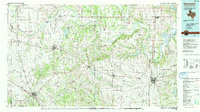 1991 Gainesville1991 Print · USGSThe Red River borderlands of Texas and Oklahoma are captured here in the early nineties, showing a region defined by cattle history and oil production. Researchers can trace the layout of historic settlements like Spanish Fort and Belcherville or locate family landmarks near Queens Peak and Moss Lake.
 - 1991 Map of Denton
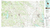 1991 Denton1991 Print · USGSNorth Texas in the early nineties shows a region transitioning between rural heritage and modern infrastructure across several counties. Genealogists and historians can trace rail lines like the Missouri Pacific or find established settlements such as Sanger, Bolivar, and Greenwood.2 unique versions available
 - 1991 Map of Charlie, 1995 Print
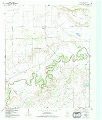 1991 Charlie1995 Print · USGSClay County near the Red River border was a landscape of petroleum production and river bottomlands in the early nineties. Genealogists and local historians can trace the roads around Charlie, find the community Cem, and locate early Oil Field sites.
End of results
Showing maps 1-3 of 3
Top cities of Clay County
- Henrietta historical maps
- Petrolia historical maps
- Byers historical maps
- Bellevue historical maps
- Dean historical maps
- Jolly historical maps
Frequently asked questions
- What are the different types of historical maps available for Clay County?
- What is the oldest map of Clay County?
- Where can I purchase historical maps of Clay County for my home or office?
- Where can I download high-res historical maps of Clay County?
- Are there historical topographic maps available for Clay County?
- Is there historical aerial imagery available for Clay County?
- Where are historical maps of Clay County sourced from?