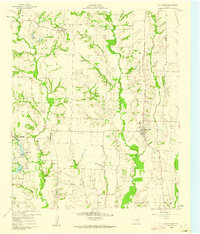
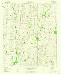
1960s Maps of Collin County, Texas
Explore 21 historic maps of Collin County from the 1960s. These maps offer a rare glimpse into what life looked like during the 1960s — showing old roads, neighborhoods, homes, and landmarks that have changed or disappeared over time.
Whether you're researching your family's past, planning a metal detecting trip, or studying how Collin County's landscape evolved across the 1960s, these high-resolution maps are a powerful tool for exploring the history of this region.
- Focus on a specific era: All maps on this page are from the 1960s, giving you a focused view of this time period.
- See what’s changed: Compare century-old streets, trails, and buildings to today's modern landscape using overlays and satellite layers.
- Research with precision: Use these maps for genealogy, historical research, land use analysis, or educational projects.
- View, download, or print: Maps are fully viewable online in high resolution, and can be downloaded or printed for your own records.
Start exploring Collin County's history through authentic maps from the 1960s. This is your window into the past.
Collin County, TX maps
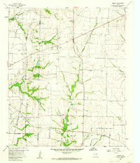
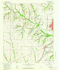
(21)- 1960 Map of Frisco, 1961 Print
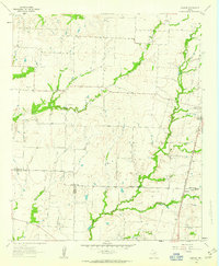
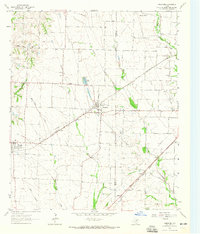
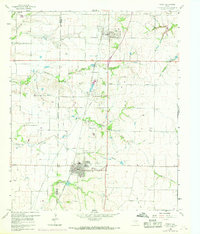
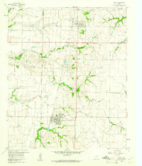 1960 Frisco1961 Print · USGSThe rural landscape of Collin County appears here just as the post-war era began to shape North Texas. Researchers can trace the early rail-side footprints of Frisco and Prosper, or locate family landmarks like Bethel Cem and the Rockhill Sch.5 unique versions available
 - 1960 Map of McKinney East, 1961 Print
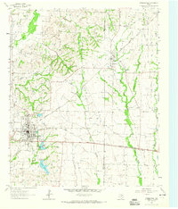
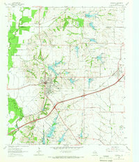
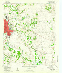 1960 McKinney East1961 Print · USGSCollin County's transition from rural farming to mid-century growth is visible here as the eastern edge of McKinney meets the river. Researchers can locate family landmarks like Pine Grove Cemetery and historic rural hubs including New Hope and Milligan.4 unique versions available
 - 1960 Map of Celina, 1961 Print
 1960 Celina1961 Print · USGSCollin and Denton counties come alive in the early sixties, showing a landscape shaped by the Frisco railroad. Genealogists can trace family footprints at Old Celina Cem, Old Union Cem, and the settlement of Alla.3 unique versions available
 - 1960 Map of Plano, 1961 Print
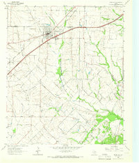
 1960 Plano1961 Print · USGSNorth Texas is documented here during the early sixties, showing Plano and Allen as distinct railroad towns before their modern suburban sprawl. Genealogists and local historians can trace the locations of Bethany Cem, Mutual Cem, and the Fanny Harrington Chapel.5 unique versions available
 - 1960 Map of Hebron, 1962 Print
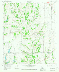
 1960 Hebron1962 Print · USGSBefore the suburban sprawl of the late twentieth century, the borderlands of Denton and Collin County remained a landscape of rural schoolhouses and family cemeteries. Trace the early footprints of Hebron and Shepton or locate landmarks like Baccus Cem and the Liberty Ch.6 unique versions available
 - 1960 Map of Blue Ridge, 1962 Print
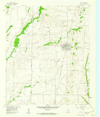
 1960 Blue Ridge1962 Print · USGSCollin County agricultural life at the start of the sixties reveals a network of small crossroads communities and family-named landmarks. Trace the locations of historic sites like Westminster Cem, Snow Hill Ch, and the old Quarries.2 unique versions available
 - 1960 Map of Pike, 1962 Print
 1960 Pike1962 Print · USGSNortheast Texas at the start of the sixties is a landscape of quiet rural junctions and family homesteads where Collin, Fannin, and Hunt counties meet. Genealogists can trace early settler footprints at Indian Creek Cem, Fuller Cem, and the small settlement of Frognot.2 unique versions available
 - 1960 Map of Culleoka, 1962 Print
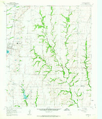
 1960 Culleoka1962 Print · USGSCollin County was a landscape of small farming communities and winding creeks in the years following the creation of Lavon Lake. Researchers can trace ancestral locations through numerous rural landmarks like Verona Ch, Henslee Chapel, and the old Gulf Colorado and Santa Fe railroad line.3 unique versions available
 - 1960 Map of McKinney West, 1962 Print
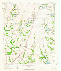
 1960 McKinney West1962 Print · USGSCollin County was on the cusp of significant growth in the early sixties as McKinney expanded westward across the creeks. Genealogists and local historians can trace family sites like McGarrah Cem, the Buckner (Site), and the Stimson Cem.4 unique versions available
 - 1961 Map of Gunter, 1963 Print
 1961 Gunter1963 Print · USGSThis early 1960s survey of the North Texas prairies captures the border between Grayson and Collin counties as the rural landscape began its modern shift. Genealogists and local historians can locate several family burial grounds, including Smallwood Cem and Forbis Cem, and trace the path of the ST LOUIS SAN FRANCISCO railroad.2 unique versions available
 - 1961 Map of Van Alstyne, 1963 Print
 1961 Van Alstyne1963 Print · USGSGrayson and Collin counties are captured here in the early sixties as agricultural life and the railroad define the landscape. Genealogists can trace family names at Morris Cem and Baker Cem or locate the rural Sister Grove Ch along the winding prongs of the local creeks.2 unique versions available
 - 1961 Map of Weston, 1963 Print
 1961 Weston1963 Print · USGSCollin County farmland is depicted in the early sixties, centered on the settlement of Weston. Genealogists and local historians can trace family-named sites like Mugg Cem, Cottage Hill Ch, and the rural crossroads of Chambersville.2 unique versions available
 - 1961 Map of Marilee, 1963 Print
 1961 Marilee1963 Print · USGSThe rural borderlands of Grayson, Denton, and Collin counties come into focus in the early sixties as the railroad era meets modern infrastructure. Trace the tracks of the St Louis San Francisco and Texas rail line through Marilee or locate local landmarks like Mt Carmel Ch and Gunter Cem.2 unique versions available
 - 1961 Map of Anna, 1963 Print
 1961 Anna1963 Print · USGSCollin County's agricultural and railroad landscapes are frozen in time here just as the early sixties began. Genealogists and historians can trace family roots through several rural burial sites like Melissa Cem and Highland Cem or locate the Independent Sch and early infrastructure like the Old Telephone Road.3 unique versions available
 - 1962 Map of Farmersville, 1965 Print
 1962 Farmersville1965 Print · USGSFarmersville and the surrounding Collin County prairie are captured here in the early sixties as a thriving rail and agricultural center. Researchers can locate vanished rural landmarks and family sites like Welford Sch, Merit Cem, and the Highmound Park Training Track.3 unique versions available
 - 1963 Map of Lavon, 1964 Print
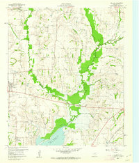
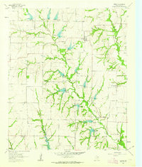
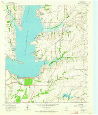 1963 Lavon1964 Print · USGSCollin County enters a new era of development in the 1960s as the rising waters of Lavon Reservoir create new shorelines. Genealogists and local historians can trace early settlements and family plots like Copeville, Nevada, and the IOOF Cem.3 unique versions available
 - 1963 Map of Josephine, 1965 Print
 1963 Josephine1965 Print · USGSNortheastern Texas farmland near the Collin and Hunt County line is captured in the early sixties, showing a landscape defined by rail and creek. Trace local family history at the Josephine Cem, Needmore Cem, or the old Community Sch.2 unique versions available
 - 1963 Map of Rockwall, 1966 Print
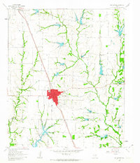
 1963 Rockwall1966 Print · USGSRockwall and the surrounding Blackland Prairie terrain are captured here in the early sixties as the region transitioned toward modern development. Researchers can trace family sites near Mt Zion Cem, the old Fate depot area, and the tracks of the Texas and Pacific Railroad.4 unique versions available
 - 1963 Map of Royse City, 1966 Print
 1963 Royse City1966 Print · USGSThe Blackland Prairies of Rockwall and Collin counties are seen here in the early sixties as rural life began to meet modern infrastructure. Genealogists can trace early family sites like Zollner Ranch or locate burials at Blackland Cem and the village Cemetery near Royse City.2 unique versions available
 - 1964 Map of Pilot Grove, 1967 Print
 1964 Pilot Grove1967 Print · USGSNear the intersection of Grayson, Fannin, and Collin counties in the mid-1960s, this rural landscape centers on the Pilot Grove Creek forks. Researchers can trace family history through local landmarks like Worden Cem, Starks Chapel Ch, and the settlement of Pilot Grove.2 unique versions available
 - 1969 Map of Frisco
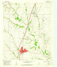
 1969 Frisco1969 Print · USGSThe North Texas prairie comes into focus during the late sixties as the rail-driven towns of Frisco and Prosper begin to grow. Genealogists can locate family burial sites like Bethel Cem and Landrum Cem nestled among traditional farm fields.
End of results
Showing maps 1-21 of 21
Top cities of Collin County
- Plano historical maps
- McKinney historical maps
- Allen historical maps
- Wylie historical maps
- Murphy historical maps
- Anna historical maps
See more
Frequently asked questions
- What are the different types of historical maps available for Collin County?
- What is the oldest map of Collin County?
- Where can I purchase historical maps of Collin County for my home or office?
- Where can I download high-res historical maps of Collin County?
- Are there historical topographic maps available for Collin County?
- Is there historical aerial imagery available for Collin County?
- Where are historical maps of Collin County sourced from?