Old Maps of Collin County, Texas for Metal Detecting
Plan your next treasure hunt with 69 historic maps of Collin County. Find old homesites, ghost towns, trails, and gathering spots that may be lost to time — perfect for identifying promising metal detecting locations.
- Locate forgotten sites: Uncover places like long-lost settlements, abandoned rail lines, or gathering spots.
- Plan better hunts: Use map overlays combined with LiDAR or satellite views to narrow in on historically rich areas.
- Made for detectorists: Thousands of hobbyists use these maps to discover relics, coins, and hidden history.
Use these historic maps to boost your research and find new opportunities beneath the surface of Collin County.
Collin County, TX maps
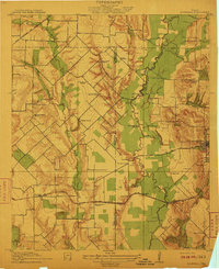
(69)- 1891 Map of Dallas
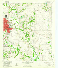
 1891 Dallas1891 Print · USGSThe Dallas area during the late nineteenth century was a rapidly growing rail hub still defined by its river crossings and rural outposts. Genealogists and historians can trace the foundations of the metroplex through early landmarks like Oak Cliff, Doddy's Ferry, and Haughts Store.
 - 1893 Map of Dallas
 1893 Dallas1893 Print · USGSDallas was a rising railroad power in the 1890s, when iron rails and river crossings dictated the growth of North Texas. Genealogists can locate vanished landmarks and rural hubs like Oak Cliff, Doddy's Ferry, and Haught's Store before the city's modern sprawl.5 unique versions available
 - 1912 Map of Rockwall
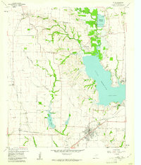
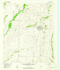
 1912 Rockwall1912 Print · USGSTexas blackland prairie and river bottoms are captured here in the years before the landscape was transformed by suburban expansion. Genealogists can locate family homesites near rural landmarks like Lewis Store, Wards Chapel, and the Elm Grove School.2 unique versions available
 - 1919 Map of Royse City
 1919 Royse City1919 Print · USGSThe agricultural heart of Northeast Texas is captured here just after the Great War, as the Blackland Prairie was crisscrossed by essential rail lines. Trace the locations of early rural landmarks like Locust Grove School, the Randle Ranch, and the vanished stop at Rockwall Station.
 - 1924 Map of Farmersville 3-c
 1924 Farmersville 3-c1924 Print · USGSIn the 1920s, southeastern Collin County was a network of railroad towns and rural school districts. Genealogists can trace family roots through landmarks like Shiloh Church, Cotton Belt School, and the settlement of Nevada.
 - 1924 Map of Mc Kinney 4-d
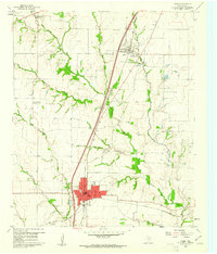
 1924 Mc Kinney 4-d1924 Print · USGSSouthern Collin County in the mid-twenties is a landscape of rural schools and vital rail connections centered on the junction at Wylie. Genealogists and researchers can trace the early footprints of settlements like Lucas and Murphy or locate vanished local landmarks such as Lone Elm School and Morris School.
 - 1929 Map of Frisco
 1929 Frisco1929 Print · USGSDenton and Collin counties appear in the mid-1920s as a landscape of rural school districts and emerging transit lines before the era of major reservoirs. Researchers can trace family-named landmarks and old transport routes like the Dallas-Denton Electric line and Hackberry Sch.2 unique versions available
 - 1929 Map of McKinney
 1929 McKinney1929 Print · USGSCollin County's rural landscape is captured here in the late twenties, before modern reservoirs reshaped the river valleys. Genealogists can trace early homesteads near local landmarks like Winningkoff Sch, Clear Lake Ch, and the rail junction at Wylie.2 unique versions available
 - 1930 Map of Farmersville
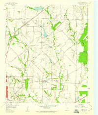
 1930 Farmersville1930 Print · USGSSoutheastern Collin County in the early twentieth century shows a landscape of rail-connected towns and rural school districts. Genealogists can locate family landmarks like Stringtown, Cairo Sch, and BUMPASS BRIDGE along the East Fork Trinity River.2 unique versions available
 - 1931 Map of Carrollton
 1931 Carrollton1931 Print · USGSCarrollton and the Elm Fork valley are captured here in the mid-twenties, when interurban rail and steam lines defined the North Texas corridor. Genealogists can trace family landmarks like Bethel Ch, Bear Creek Sch, and the rural community at Trinity Mills.3 unique versions available
 - 1954 Map of Dallas, 1963 Print
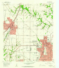
 1954 Dallas1963 Print · USGSNorth Texas in the mid-fifties and early sixties reveals a landscape of rapid urban growth and water management. Genealogists and historians can trace the evolution of the metroplex through landmarks like Hensley Field, Boles Orphan Home, and the Texas & Pacific RR.4 unique versions available
 - 1954 Map of Sherman, 1964 Print
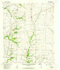
 1954 Sherman1964 Print · USGSThe Red River valley and North Texas plains are captured here in the mid-fifties, showing the region as new reservoirs like Lake Texoma and Lavon Reservoir reshaped the land. Genealogists can trace family roots through specific local landmarks like Courtney P O, Pilot Grove Sch, and New Hope Ch.2 unique versions available
 - 1958 Map of Dallas
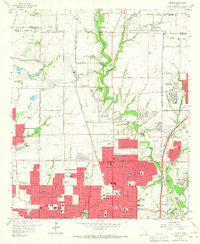
 1958 Dallas1958 Print · USGSNorth Texas in the late fifties shows the dramatic expansion of the Metroplex as it absorbs surrounding farm towns. Genealogists and historians can trace old rail lines like the Missouri-Kansas-Texas and locate early lakefront developments at Eagle Mountain Lake and Lake Worth Village.
 - 1958 Map of Sherman, 1959 Print
 1958 Sherman1959 Print · USGSNorth Texas and Southern Oklahoma were undergoing significant development in the late fifties as the Red River Valley transit networks matured. Researchers can trace historic family-named locations such as Saddler Bend, the grounds of Perrin AFB, and early shoreline developments at Lake Texoma.
 - 1959 Map of Garland, 1960 Print
 1959 Garland1960 Print · USGSNortheast Dallas County is shown here in the late fifties, just as the postwar suburban boom began to reshape the countryside. Genealogists and historians can trace family-named sites like Blewett Cem and early communities such as Audelia and Shiloh.5 unique versions available
 - 1959 Map of Addison, 1960 Print
 1959 Addison1960 Print · USGSThe northern fringes of Dallas were transforming from rural farmsteads to suburban hubs during the late fifties. Genealogists and historians can trace the growth of local institutions like Ursuline Academy, the Addison Sch, and the historic White Rock Cem.6 unique versions available
 - 1959 Map of Rowlett, 1960 Print
 1959 Rowlett1960 Print · USGSThe Rowlett and Garland area of North Texas is captured here in the late fifties, showcasing a rural landscape before its rapid suburban transformation. Genealogists and historians can trace family-named sites like Watson Sch, McShan Cem, and the settlement of Dalrock.6 unique versions available
 - 1959 Map of Wylie, 1961 Print
 1959 Wylie1961 Print · USGSCollin County during the late fifties shows the rising importance of water management and rail transit in North Texas. Genealogists and local historians can locate many family sites, from the St Paul Cem to the railroad junction at Wylie and the community of Winningkoff.4 unique versions available
 - 1959 Map of Garland, 1963 Print
 1959 Garland1963 Print · USGSEastern Dallas County is captured in the late fifties as small towns begin to merge into a growing suburban landscape. Genealogists and historians can trace local family roots at Blewett Cem and see the early footprints of Richardson, Sunnyvale, and the White Rock Airport.
 - 1959 Map of Carrollton, 1963 Print
 1959 Carrollton1963 Print · USGSNorth Dallas and its surrounding suburbs are captured during a period of massive suburban growth in the late fifties. Genealogists can trace family sites near Trinity Mills, while researchers can locate mid-century landmarks like Love Field Municipal Airport and Calvary Hill Cemetery.
 - 1960 Map of Frisco, 1961 Print
 1960 Frisco1961 Print · USGSThe rural landscape of Collin County appears here just as the post-war era began to shape North Texas. Researchers can trace the early rail-side footprints of Frisco and Prosper, or locate family landmarks like Bethel Cem and the Rockhill Sch.5 unique versions available
 - 1960 Map of McKinney East, 1961 Print
 1960 McKinney East1961 Print · USGSCollin County's transition from rural farming to mid-century growth is visible here as the eastern edge of McKinney meets the river. Researchers can locate family landmarks like Pine Grove Cemetery and historic rural hubs including New Hope and Milligan.4 unique versions available
 - 1960 Map of Celina, 1961 Print
 1960 Celina1961 Print · USGSCollin and Denton counties come alive in the early sixties, showing a landscape shaped by the Frisco railroad. Genealogists can trace family footprints at Old Celina Cem, Old Union Cem, and the settlement of Alla.3 unique versions available
 - 1960 Map of Plano, 1961 Print
 1960 Plano1961 Print · USGSNorth Texas is documented here during the early sixties, showing Plano and Allen as distinct railroad towns before their modern suburban sprawl. Genealogists and local historians can trace the locations of Bethany Cem, Mutual Cem, and the Fanny Harrington Chapel.5 unique versions available
 - 1960 Map of Hebron, 1962 Print
 1960 Hebron1962 Print · USGSBefore the suburban sprawl of the late twentieth century, the borderlands of Denton and Collin County remained a landscape of rural schoolhouses and family cemeteries. Trace the early footprints of Hebron and Shepton or locate landmarks like Baccus Cem and the Liberty Ch.6 unique versions available
Showing maps 1-25 of 69
Top cities of Collin County
- Plano historical maps
- McKinney historical maps
- Allen historical maps
- Wylie historical maps
- Murphy historical maps
- Anna historical maps
See more
Frequently asked questions
- What are the different types of historical maps available for Collin County?
- What is the oldest map of Collin County?
- Where can I purchase historical maps of Collin County for my home or office?
- Where can I download high-res historical maps of Collin County?
- Are there historical topographic maps available for Collin County?
- Is there historical aerial imagery available for Collin County?
- Where are historical maps of Collin County sourced from?