1960s Maps of Farmersville, Texas
Explore 2 historic maps of Farmersville from the 1960s. These maps offer a rare glimpse into what life looked like during the 1960s — showing old roads, neighborhoods, homes, and landmarks that have changed or disappeared over time.
Whether you're researching your family's past, planning a metal detecting trip, or studying how Farmersville's landscape evolved across the 1960s, these high-resolution maps are a powerful tool for exploring the history of this region.
- Focus on a specific era: All maps on this page are from the 1960s, giving you a focused view of this time period.
- See what’s changed: Compare century-old streets, trails, and buildings to today's modern landscape using overlays and satellite layers.
- Research with precision: Use these maps for genealogy, historical research, land use analysis, or educational projects.
- View, download, or print: Maps are fully viewable online in high resolution, and can be downloaded or printed for your own records.
Start exploring Farmersville's history through authentic maps from the 1960s. This is your window into the past.
Farmersville, TX maps
(2)- 1960 Map of Culleoka, 1962 Print
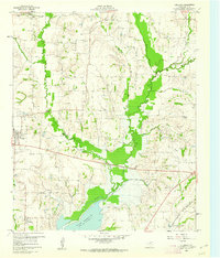 1960 Culleoka1962 Print · USGSCollin County was a landscape of small farming communities and winding creeks in the years following the creation of Lavon Lake. Researchers can trace ancestral locations through numerous rural landmarks like Verona Ch, Henslee Chapel, and the old Gulf Colorado and Santa Fe railroad line.3 unique versions available
 - 1962 Map of Farmersville, 1965 Print
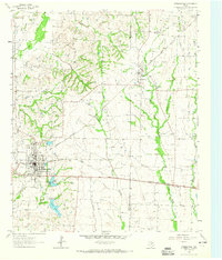 1962 Farmersville1965 Print · USGSFarmersville and the surrounding Collin County prairie are captured here in the early sixties as a thriving rail and agricultural center. Researchers can locate vanished rural landmarks and family sites like Welford Sch, Merit Cem, and the Highmound Park Training Track.3 unique versions available
End of results
Showing maps 1-2 of 2
Top cities near Farmersville
- Dallas historical maps
- Garland historical maps
- McKinney historical maps
- Rowlett historical maps
- Rockwall historical maps
- Wylie historical maps
See more
Frequently asked questions
- What are the different types of historical maps available for Farmersville?
- What is the oldest map of Farmersville?
- Where can I purchase historical maps of Farmersville for my home or office?
- Where can I download high-res historical maps of Farmersville?
- Are there historical topographic maps available for Farmersville?
- Is there historical aerial imagery available for Farmersville?
- Where are historical maps of Farmersville sourced from?