1960s Maps of Plano, Texas
Explore 3 historic maps of Plano from the 1960s. These maps offer a rare glimpse into what life looked like during the 1960s — showing old roads, neighborhoods, homes, and landmarks that have changed or disappeared over time.
Whether you're researching your family's past, planning a metal detecting trip, or studying how Plano's landscape evolved across the 1960s, these high-resolution maps are a powerful tool for exploring the history of this region.
- Focus on a specific era: All maps on this page are from the 1960s, giving you a focused view of this time period.
- See what’s changed: Compare century-old streets, trails, and buildings to today's modern landscape using overlays and satellite layers.
- Research with precision: Use these maps for genealogy, historical research, land use analysis, or educational projects.
- View, download, or print: Maps are fully viewable online in high resolution, and can be downloaded or printed for your own records.
Start exploring Plano's history through authentic maps from the 1960s. This is your window into the past.
Plano, TX maps
(3)- 1960 Map of Plano, 1961 Print
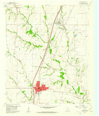 1960 Plano1961 Print · USGSNorth Texas is documented here during the early sixties, showing Plano and Allen as distinct railroad towns before their modern suburban sprawl. Genealogists and local historians can trace the locations of Bethany Cem, Mutual Cem, and the Fanny Harrington Chapel.5 unique versions available
 - 1960 Map of Hebron, 1962 Print
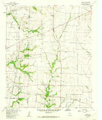 1960 Hebron1962 Print · USGSBefore the suburban sprawl of the late twentieth century, the borderlands of Denton and Collin County remained a landscape of rural schoolhouses and family cemeteries. Trace the early footprints of Hebron and Shepton or locate landmarks like Baccus Cem and the Liberty Ch.6 unique versions available
 - 1960 Map of McKinney West, 1962 Print
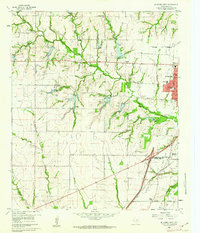 1960 McKinney West1962 Print · USGSCollin County was on the cusp of significant growth in the early sixties as McKinney expanded westward across the creeks. Genealogists and local historians can trace family sites like McGarrah Cem, the Buckner (Site), and the Stimson Cem.4 unique versions available
End of results
Showing maps 1-3 of 3
Top cities near Plano
- Dallas historical maps
- Irving historical maps
- Garland historical maps
- Frisco historical maps
- McKinney historical maps
- Mesquite historical maps
See more
Top neighborhoods of Plano
- Cowley historical maps
- Prestondale historical maps
- Wyndemere historical maps
- Preston Square historical maps
- Robin's Place historical maps
- Turnberry Village historical maps
Frequently asked questions
- What are the different types of historical maps available for Plano?
- What is the oldest map of Plano?
- Where can I purchase historical maps of Plano for my home or office?
- Where can I download high-res historical maps of Plano?
- Are there historical topographic maps available for Plano?
- Is there historical aerial imagery available for Plano?
- Where are historical maps of Plano sourced from?