1960s Maps of Spring Branch, Texas
Explore 2 historic maps of Spring Branch from the 1960s. These maps offer a rare glimpse into what life looked like during the 1960s — showing old roads, neighborhoods, homes, and landmarks that have changed or disappeared over time.
Whether you're researching your family's past, planning a metal detecting trip, or studying how Spring Branch's landscape evolved across the 1960s, these high-resolution maps are a powerful tool for exploring the history of this region.
- Focus on a specific era: All maps on this page are from the 1960s, giving you a focused view of this time period.
- See what’s changed: Compare century-old streets, trails, and buildings to today's modern landscape using overlays and satellite layers.
- Research with precision: Use these maps for genealogy, historical research, land use analysis, or educational projects.
- View, download, or print: Maps are fully viewable online in high resolution, and can be downloaded or printed for your own records.
Start exploring Spring Branch's history through authentic maps from the 1960s. This is your window into the past.
Spring Branch, TX maps
(2)- 1964 Map of Spring Branch, 1967 Print
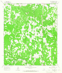 1964 Spring Branch1967 Print · USGSTexas hill country life in the mid-1960s is centered here on the Guadalupe River and the settlement of Spring Branch. You can trace rural landmarks from the Spring Branch PO to the Twin Sisters peaks and the small community of Knibbe.2 unique versions available
 - 1964 Map of Anhalt, 1968 Print
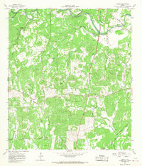 1964 Anhalt1968 Print · USGSComal County rural life in the mid-1960s is preserved here, showing the Texas Hill Country's network of family homesteads and local creeks. Genealogists can trace family lines through sites like Beierle Cem, St Joseph Chapel, and Farmers Hall.3 unique versions available
End of results
Showing maps 1-2 of 2
Top cities near Spring Branch
- San Antonio historical maps
- New Braunfels historical maps
- Fair Oaks Ranch historical maps
- Bulverde historical maps
- Garden Ridge historical maps
- Blanco historical maps
See more
Frequently asked questions
- What are the different types of historical maps available for Spring Branch?
- What is the oldest map of Spring Branch?
- Where can I purchase historical maps of Spring Branch for my home or office?
- Where can I download high-res historical maps of Spring Branch?
- Are there historical topographic maps available for Spring Branch?
- Is there historical aerial imagery available for Spring Branch?
- Where are historical maps of Spring Branch sourced from?