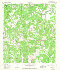
1964 Map of Anhalt
USGS Topo · Published 1968About this map
The Guadalupe River carves through the northern reaches of this Hill Country landscape, joined by numerous seasonal drainages like Honey Creek and Swine Creek. German heritage is visible in the dense concentration of family cemeteries and community sites scattered across the terrain, including the Kabelmacher Cem, Scheel Cem, and Koch Cem. The settlement of Anhalt is a central focal point, while the southern edge of the sheet shows the early development of the Bulverde Community Center and the Bulverde Sch. Numerous gravel pits and quarries along the river and Hanz Creek point to the local importance of resource extraction during the mid-1960s. High points like Devils Hill offer a sense of the undulating topography that defined the rural character of Comal County before the expansion of nearby urban centers.
Find a feature on this map
36 named features on this map. Tap any name to fly to it.
Don’t see what you’re looking for? This feature index may not catch every label — zoom into the map to look around manually.
Map Details
Editions of this 1964 Anhalt Map
3 editions found
Other maps of this area

1920 · Smithsons Valley
USGS Topo · 1:62,500

1925 · Smithson Valley No. 1
USGS Topo · 1:48,000

1927 · Smithson Valley
USGS Topo · 1:62,500

1929 · Smithson Valley
USGS Topo · 1:62,500

1940 · Smithson Valley
USGS Topo · 1:62,500

1953 · Otis Ridge
USGS Topo · 1:24,000

1953 · Bulverde
USGS Topo · 1:24,000

1953 · Bat Cave
USGS Topo · 1:24,000

1954 · San Antonio
USGS Topo · 1:250,000

1957 · Boerne
USGS Topo · 1:62,500