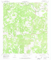
1964 Map of Anhalt
USGS Topo · Published 1975About this map
The Anhalt community, centered around the landmark Farmers Hall, defines this 1964 portrait of Comal and Kendall counties. The landscape is heavily marked by German family heritage, evidenced by a dense network of private burial grounds including Kabelmacher Cem, Scheel Cem, and Krause Cem. The rugged limestone topography rises toward Devils Hill, with numerous gravel pits scattered throughout the drainage basins of Swine Creek and Honey Creek. To the south, the Bulverde Sch and Bulverde Community Center serve as anchors for the local rural population. The northern portion of the map follows the winding course of the Guadalupe River, where the confluence of Spring Branch and Cypress Creek creates a complex system of riparian draws. This survey captures a specific mid-century Texas Hill Country era before significant suburban development reached these family-held ranching and farming lands.
Find a feature on this map
36 named features on this map. Tap any name to fly to it.
Don’t see what you’re looking for? This feature index may not catch every label — zoom into the map to look around manually.
Map Details
Editions of this 1964 Anhalt Map
3 editions found
Other maps of this area

1920 · Smithsons Valley
USGS Topo · 1:62,500

1925 · Smithson Valley No. 1
USGS Topo · 1:48,000

1927 · Smithson Valley
USGS Topo · 1:62,500

1929 · Smithson Valley
USGS Topo · 1:62,500

1940 · Smithson Valley
USGS Topo · 1:62,500

1953 · Otis Ridge
USGS Topo · 1:24,000

1953 · Bulverde
USGS Topo · 1:24,000

1953 · Bat Cave
USGS Topo · 1:24,000

1954 · San Antonio
USGS Topo · 1:250,000

1957 · Boerne
USGS Topo · 1:62,500