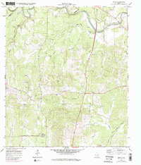
1964 Map of Anhalt
USGS Topo · Published 1975About this map
Anhalt and the surrounding Hill Country landscape of Comal County are captured here in a 1964 survey, showing the rural Texas settlement patterns before significant modern suburban expansion. The map is exceptionally detailed regarding family heritage, documenting numerous private burial sites such as Kabelmacher Cem, Beierle Cem, and Krause Cem. These small cemeteries, alongside landmarks like Farmers Hall and St Joseph Chapel, provide a clear picture of the community's German-Texan roots and social centers. The winding course of the Guadalupe River and its tributaries, including Honey Creek and Swine Creek, dictate the local topography, while gravel pits and quarries scattered near Ahern and Hanz Creek point to the area's geological resource extraction. Farther south, the Bulverde Community Center and Bulverde Sch anchor the burgeoning townsite along Ammann Road.
Find a feature on this map
38 named features on this map. Tap any name to fly to it.
Don’t see what you’re looking for? This feature index may not catch every label — zoom into the map to look around manually.
Map Details
Editions of this 1964 Anhalt Map
3 editions found
Other maps of this area

1920 · Smithsons Valley
USGS Topo · 1:62,500

1925 · Smithson Valley No. 1
USGS Topo · 1:48,000

1927 · Smithson Valley
USGS Topo · 1:62,500

1929 · Smithson Valley
USGS Topo · 1:62,500

1940 · Smithson Valley
USGS Topo · 1:62,500

1953 · Otis Ridge
USGS Topo · 1:24,000

1953 · Bulverde
USGS Topo · 1:24,000

1953 · Bat Cave
USGS Topo · 1:24,000

1954 · San Antonio
USGS Topo · 1:250,000

1957 · Boerne
USGS Topo · 1:62,500