1900s (20th Century) Maps of Concho County, Texas
Explore 42 historic maps of Concho County from the 1900s (20th Century). These maps offer a rare glimpse into what life looked like during the 1900s — showing old roads, neighborhoods, homes, and landmarks that have changed or disappeared over time.
Whether you're researching your family's past, planning a metal detecting trip, or studying how Concho County's landscape evolved across the 1900s, these high-resolution maps are a powerful tool for exploring the history of this region.
- Focus on a specific era: All maps on this page are from the 1900s, giving you a focused view of this time period.
- See what’s changed: Compare century-old streets, trails, and buildings to today's modern landscape using overlays and satellite layers.
- Research with precision: Use these maps for genealogy, historical research, land use analysis, or educational projects.
- View, download, or print: Maps are fully viewable online in high resolution, and can be downloaded or printed for your own records.
Start exploring Concho County's history through authentic maps from the 1900s. This is your window into the past.
Concho County, TX maps
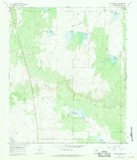
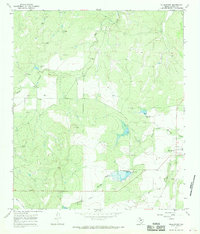
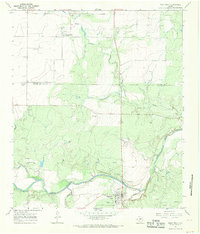
(42)- 1921 Map of Lowake
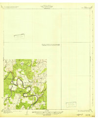
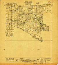 1921 Lowake1921 Print · USGSLowake and the Concho County ranchlands are captured here in the early 1920s as the railroad drove local commerce. Genealogists and historians can trace the locations of rural schoolhouses like Sweet Home School and Green Wall School near the banks of Little Concho Creek.
 - 1924 Map of Eden 1-a
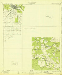
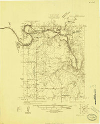 1924 Eden 1-a1924 Print · USGSThe Concho and Colorado River confluence area was a landscape of river crossings and small schoolhouse districts in the mid-1920s. Genealogists can trace early homesteads near Stacy and Doole, or locate landmarks like Bethel Church and the Hardin School.
 - 1925 Map of Ballinger 3-d
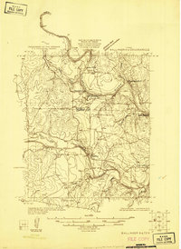 1925 Ballinger 3-d1925 Print · USGSThe convergence of the Colorado and Concho Rivers is captured here in the mid-1920s as ranching life centered on the water. Local historians can locate river crossings like Hall Ford and rural educational sites such as Mapes School and Currie School.
 - 1925 Map of Ballinger 4-c
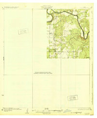
 1925 Ballinger 4-c1925 Print · USGSCentral West Texas river valleys are surveyed in the mid-1920s at the junction of three counties. Researchers can locate early rural landmarks like Liberty School and historic river crossings such as Coffee Ford and Trap Crossing.
 - 1931 Map of Stacy
 1931 Stacy1931 Print · USGSCentral Texas ranching country comes into focus during the 1920s as the river defines three county lines. Genealogists can locate rural schoolhouses like Hardin Sch and Williams Sch or trace old river fords at Crane Crossing.2 unique versions available
 - 1932 Map of Voss
 1932 Voss1932 Print · USGSCentral Texas river life in the mid-1920s is documented here along the winding banks of the Concho River. Genealogists and local historians can trace the community of Leaday and several rural schoolhouses like Liberty Sch and Redwire Sch.2 unique versions available
 - 1932 Map of Paint Rock
 1932 Paint Rock1932 Print · USGSThe northern edge of the Edwards Plateau comes into focus in the early 1930s as the rail lines reached into Concho County. Genealogists and historians can trace the rural school districts of the day, including Dry Ridge Sch and Mapes Sch, or locate the family-named bluffs along the Concho River.2 unique versions available
 - 1954 Map of Brownwood, 1955 Print
 1954 Brownwood1955 Print · USGSCentral Texas in the early fifties shows a landscape of rail-linked cattle towns and winding river valleys before modern highway expansion. Genealogists and historians can trace family-named peaks and vanished rail stops like Trickham, Santa Anna, and the Brady Mountains.3 unique versions available
 - 1954 Map of San Angelo, 1967 Print
 1954 San Angelo1967 Print · USGSThe Concho Valley and eastern Permian Basin transition from ranching to a burgeoning oil economy during the mid-twentieth century. Trace the expansion of San Angelo near Goodfellow AFB and locate old crossroads like Stiles, Texon, and Barnhart along the SANTA FE railroad.2 unique versions available
 - 1957 Map of Eola, 1958 Print
 1957 Eola1958 Print · USGSThe rural landscapes of Tom Green and Concho counties are captured here in the late fifties, during a period of steady oil and ranching activity. Genealogists can trace family footprints through the Lakeview Community Cem, the old Dry Hollow Sch (Aband), and early settlements like Mereta and Vancourt.
 - 1957 Map of Miles, 1958 Print
 1957 Miles1958 Print · USGSRunnels and Tom Green Counties are shown in the late fifties as the regional economy balanced between rail-side agriculture and a growing oil industry. Genealogists can locate several burial sites including Evergreen Cem and Protestant Cem, or trace early river crossings like 10 Mile Crossing.
 - 1958 Map of San Angelo
 1958 San Angelo1958 Print · USGSWest Texas in the late fifties centers on the growing hub of San Angelo and its vital river confluences. Genealogists and historians can trace the paths of the Santa Fe railroad to outposts like Fort Chadbourne, Big Lake, and the specialized community of Sanatorium.
 - 1960 Map of Melvin, 1961 Print
 1960 Melvin1961 Print · USGSMcCulloch County in the early sixties centers on the rail-side community of Melvin as it navigates the landscape of the BRADY MOUNTAINS. Researchers can trace the path of the GULF COLORADO AND SANTA FE railroad through Whiteland and Homer Junction or locate family plots at Melvin Cem.2 unique versions available
 - 1965 Map of San Angelo
 1965 San Angelo1965 Print · USGSWest Texas in the mid-sixties reveals a landscape shaped by the petroleum industry and strategic water management. Genealogists and historians can trace the rail corridor through Texon and Big Lake, or locate military landmarks like Goodfellow AFB and Broome Air Force Auxiliary Airfield.
 - 1967 Map of Millersview SE, 1969 Print
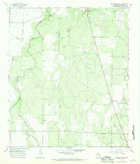
 1967 Millersview SE1969 Print · USGSCentral Texas during the late sixties shows a landscape shaped by water management and resource extraction. Trace the network of reservoirs and spillways along Duck Creek or locate local industrial sites like the various Gravel Pits.2 unique versions available
 - 1967 Map of Concho, 1969 Print
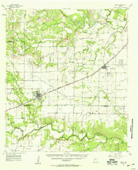
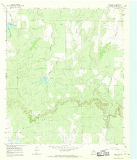
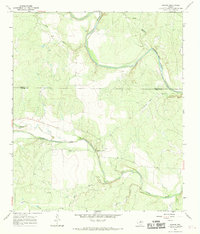 1967 Concho1969 Print · USGSThe Texas ranchlands at the Concho and Colorado River confluence appear in high detail during the late sixties. Local researchers can trace the rural settlement of Concho, locate the community Cem, and explore the riverfront near Deadmans Bluff and Fuzzy.3 unique versions available
 - 1967 Map of Doole, 1969 Print
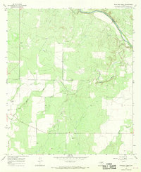
 1967 Doole1969 Print · USGSCentral Texas ranching country comes into focus in the late sixties along the winding Colorado River. Local historians can trace family roots around Stacy and Doole, or locate the rural Cem and isolated landmarks like Wallooppe.
 - 1967 Map of Salt Gap, 1969 Print
 1967 Salt Gap1969 Print · USGSThe border of Concho and McCulloch counties comes alive in the late sixties as the ranching country meets the Brady Mountains. Genealogists and researchers can trace the roads around Salt Gap and locate family landmarks like Rattlesnake Point or Little Saddle Creek.2 unique versions available
 - 1967 Map of Millersview, 1969 Print
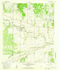
 1967 Millersview1969 Print · USGSIn the late 1960s, the ranching and resource lands of Concho County centered on the small crossroads of Millersview. Researchers can trace the development of local water projects near North Fork Mustang Creek or locate numerous early Oil Wells and Gas Wells.2 unique versions available
 - 1967 Map of Doole SW, 1969 Print
 1967 Doole SW1969 Print · USGSConcho County ranch lands spread across the northern slopes of the plateau in the late sixties. Researchers can trace the drainage of Middle Fork Mustang Creek and identify landmarks like the Brady Mountains and Waloope Creek.
 - 1967 Map of Voss, 1969 Print
 1967 Voss1969 Print · USGSNear the Coleman and Concho county line in the late sixties, this survey shows a landscape of West Texas ranching and riverside terrain. Researchers can locate the settlement of Voss, the Hill Cem, and the dramatic loop of the Colorado R at Horseshoe Bend.2 unique versions available
 - 1967 Map of Mustang Creek, 1969 Print
 1967 Mustang Creek1969 Print · USGSConcho County ranching and river lands are captured here in the late sixties, just as the regional landscape was mapped in high detail. Researchers can trace land boundaries through Stevens Ranch, locate the Millersview Cem, and follow the many forks of Mustang Creek.3 unique versions available
 - 1967 Map of Leaday, 1969 Print
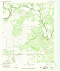
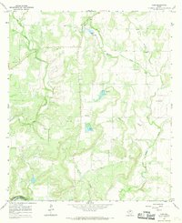
 1967 Leaday1969 Print · USGSThe convergence of the Colorado and Concho Rivers defines this Central Texas landscape in the late sixties. Genealogists can locate family burial sites at Gann Cem and Leaday Cem, or trace the winding course of Little Grape Creek.2 unique versions available
 - 1967 Map of Paint Rock, 1969 Print
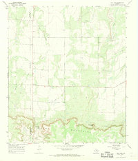
 1967 Paint Rock1969 Print · USGSThe Concho River valley in the late sixties reveals a landscape of ancient history and mid-century utility at the county line. Researchers can trace the layout of Paint Rock and Olfen, or locate landmarks like the Indian Pictographs and St Boniface Ch.2 unique versions available
 - 1967 Map of Millersview NW, 1970 Print
 1967 Millersview NW1970 Print · USGSConcho County ranch land in the late sixties shows a landscape shaped by livestock, oil, and gravel. Local researchers can locate family burial sites like Paint Rock Cem and Kersh Grave among the waters of Kickapoo Creek.2 unique versions available
Showing maps 1-25 of 42
Top cities of Concho County
Frequently asked questions
- What are the different types of historical maps available for Concho County?
- What is the oldest map of Concho County?
- Where can I purchase historical maps of Concho County for my home or office?
- Where can I download high-res historical maps of Concho County?
- Are there historical topographic maps available for Concho County?
- Is there historical aerial imagery available for Concho County?
- Where are historical maps of Concho County sourced from?