1960s Maps of Paint Rock, Texas
Explore 2 historic maps of Paint Rock from the 1960s. These maps offer a rare glimpse into what life looked like during the 1960s — showing old roads, neighborhoods, homes, and landmarks that have changed or disappeared over time.
Whether you're researching your family's past, planning a metal detecting trip, or studying how Paint Rock's landscape evolved across the 1960s, these high-resolution maps are a powerful tool for exploring the history of this region.
- Focus on a specific era: All maps on this page are from the 1960s, giving you a focused view of this time period.
- See what’s changed: Compare century-old streets, trails, and buildings to today's modern landscape using overlays and satellite layers.
- Research with precision: Use these maps for genealogy, historical research, land use analysis, or educational projects.
- View, download, or print: Maps are fully viewable online in high resolution, and can be downloaded or printed for your own records.
Start exploring Paint Rock's history through authentic maps from the 1960s. This is your window into the past.
Paint Rock, TX maps
(2)- 1967 Map of Paint Rock, 1969 Print
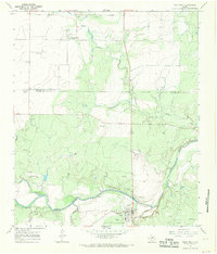 1967 Paint Rock1969 Print · USGSThe Concho River valley in the late sixties reveals a landscape of ancient history and mid-century utility at the county line. Researchers can trace the layout of Paint Rock and Olfen, or locate landmarks like the Indian Pictographs and St Boniface Ch.2 unique versions available
 - 1967 Map of Millersview NW, 1970 Print
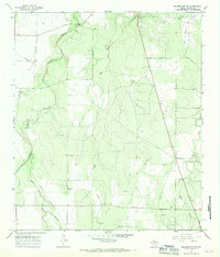 1967 Millersview NW1970 Print · USGSConcho County ranch land in the late sixties shows a landscape shaped by livestock, oil, and gravel. Local researchers can locate family burial sites like Paint Rock Cem and Kersh Grave among the waters of Kickapoo Creek.2 unique versions available
End of results
Showing maps 1-2 of 2
Top cities near Paint Rock
Frequently asked questions
- What are the different types of historical maps available for Paint Rock?
- What is the oldest map of Paint Rock?
- Where can I purchase historical maps of Paint Rock for my home or office?
- Where can I download high-res historical maps of Paint Rock?
- Are there historical topographic maps available for Paint Rock?
- Is there historical aerial imagery available for Paint Rock?
- Where are historical maps of Paint Rock sourced from?