1990s Maps of Coryell County, Texas
Explore 14 historic maps of Coryell County from the 1990s. These maps offer a rare glimpse into what life looked like during the 1990s — showing old roads, neighborhoods, homes, and landmarks that have changed or disappeared over time.
Whether you're researching your family's past, planning a metal detecting trip, or studying how Coryell County's landscape evolved across the 1990s, these high-resolution maps are a powerful tool for exploring the history of this region.
- Focus on a specific era: All maps on this page are from the 1990s, giving you a focused view of this time period.
- See what’s changed: Compare century-old streets, trails, and buildings to today's modern landscape using overlays and satellite layers.
- Research with precision: Use these maps for genealogy, historical research, land use analysis, or educational projects.
- View, download, or print: Maps are fully viewable online in high resolution, and can be downloaded or printed for your own records.
Start exploring Coryell County's history through authentic maps from the 1990s. This is your window into the past.
Coryell County, TX maps
(14)- 1994 Map of McMillan Mountains
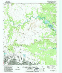
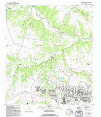
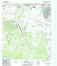 1994 McMillan Mountains1994 Print · USGSCentral Texas in the early nineties shows the expansion of Killeen alongside the Fort Hood Military Reservation. Researchers can locate several family burial grounds like Mayberry Cem and Sibley Cem, or trace landmarks like Crossville Mountain and Montague Village.
 - 1994 Map of North Fort Hood, 1995 Print
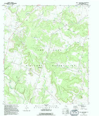
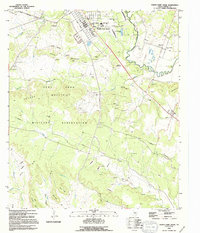 1994 North Fort Hood1995 Print · USGSCoryell County during the mid-1990s shows the massive footprint of the Fort Hood Military Reservation alongside established rural communities. Researchers can trace historic family locations at Hubbard Cem or Bethel Cem and see the rail-and-river geography near Mound.
 - 1994 Map of Oglesby, 1995 Print
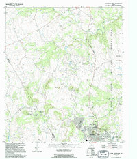
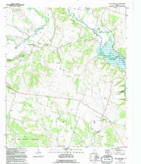
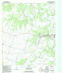
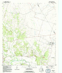 1994 Oglesby1995 Print · USGSIn the early 1990s, the Oglesby area showcased a mix of rural community life and specialized industrial footprints near the Leon River. Researchers can trace historical sites like Lime City (Site), several family-named cemeteries including Davidson Cem, and the Naval Weapons Industrial Reserve Plant.
 - 1994 Map of Gatesville East, 1995 Print
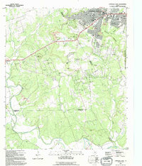
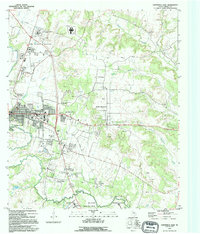 1994 Gatesville East1995 Print · USGSCoryell County during the mid-nineties shows the distinct intersection of civic life in GATESVILLE and the massive FORT HOOD MILITARY RESERVATION. Local historians can trace family plots at Restland Cem and Oak Grove Cem, or locate the Historical Marker Fort Gates near the river.
 - 1994 Map of Post Oak Mountain, 1995 Print
 1994 Post Oak Mountain1995 Print · USGSThe northern edge of Killeen meets the sprawling training grounds of the Fort Hood Military Reservation during the mid-nineties. Researchers can trace the military infrastructure of Hood Army Airfield and the residential streets of Walker Village alongside landmarks like Post Oak Mountain.
 - 1995 Map of Shell Mountains
 1995 Shell Mountains1995 Print · USGSCoryell County during the mid-nineties shows the transition from historic family ranchlands to restricted military use. Researchers can trace land markers like Walker Cem and White Cem or locate geographical features such as Stampede Mountain and Shell Gap.
 - 1995 Map of Twin Mountains
 1995 Twin Mountains1995 Print · USGSThe rapid expansion of Copperas Cove meets the eastern boundary of the Fort Hood Military Reservation in the mid-nineties. Researchers can locate local landmarks like the Twin Mountains Cem, Lovel Ledger Sch, and family-named features like Herzog Mountain.
 - 1995 Map of Copperas Cove
 1995 Copperas Cove1995 Print · USGSCopperas Cove and Kempner are captured in the mid-1990s as suburban development meets the sprawling ranch lands of central Texas. Genealogists can trace long-standing family ties through sites like Kempner Cem, Ethridge Cem, and Oak Hills Ch.
 - 1995 Map of Fort Hood
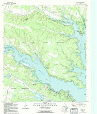
 1995 Fort Hood1995 Print · USGSFort Hood and its surrounding training grounds are captured here in the mid-nineties, showing the integration of military life and tactical terrain. Researchers can locate residential areas like Comanche Village II and McNair Village, or trace the path of the Monorail near Jack Mountain.
 - 1995 Map of Leon Junction
 1995 Leon Junction1995 Print · USGSCoryell County during the mid-nineties shows a rural landscape where traditional ranching terrain meets modern conservation and military interests. Genealogists can locate family landmarks like Seeton Cem or Flint Creek Cemetery and trace the former path of the Old Railroad Grade.
 - 1995 Map of Bland
 1995 Bland1995 Print · USGSThe Bell and Coryell county line in the mid-1990s shows the convergence of military training and lakefront recreation. Genealogists and locals can trace rural landmarks like Union Hill and Liberty Hill alongside the Fort Hood Military Reservation.
 - 1995 Map of Purmela
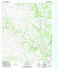
 1995 Purmela1995 Print · USGSCoryell County during the mid-nineties shows a rural Texas landscape centered on the winding Cowhouse Creek. Researchers can trace old family sites and rural landmarks like Smith Cem, South Purmela, and the elevations of Culp Mountain.
 - 1995 Map of Gatesville West
 1995 Gatesville West1995 Print · USGSCoryell County during the mid-nineties shows the western growth of the county seat alongside major military and state institutions. Genealogists and local historians can locate Hermeline Cem, Standifer Chapel, and the Old Railroad Grade near the Leon River.
 - 1995 Map of Pidcoke
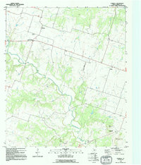
 1995 Pidcoke1995 Print · USGSCoryell County is captured here in the mid-1990s, showing the intersection of rural ranching life and expanding military infrastructure. Researchers can locate family landmarks such as the Pidcoke Cemetery, the settlement of Slater, and the rugged Table Rock formation.
End of results
Showing maps 1-14 of 14
Top cities of Coryell County
- Copperas Cove historical maps
- Gatesville historical maps
- Oglesby historical maps
- South Mountain historical maps
Frequently asked questions
- What are the different types of historical maps available for Coryell County?
- What is the oldest map of Coryell County?
- Where can I purchase historical maps of Coryell County for my home or office?
- Where can I download high-res historical maps of Coryell County?
- Are there historical topographic maps available for Coryell County?
- Is there historical aerial imagery available for Coryell County?
- Where are historical maps of Coryell County sourced from?