1940s Maps of Copperas Cove, Texas
Explore 4 historic maps of Copperas Cove from the 1940s. These maps offer a rare glimpse into what life looked like during the 1940s — showing old roads, neighborhoods, homes, and landmarks that have changed or disappeared over time.
Whether you're researching your family's past, planning a metal detecting trip, or studying how Copperas Cove's landscape evolved across the 1940s, these high-resolution maps are a powerful tool for exploring the history of this region.
- Focus on a specific era: All maps on this page are from the 1940s, giving you a focused view of this time period.
- See what’s changed: Compare century-old streets, trails, and buildings to today's modern landscape using overlays and satellite layers.
- Research with precision: Use these maps for genealogy, historical research, land use analysis, or educational projects.
- View, download, or print: Maps are fully viewable online in high resolution, and can be downloaded or printed for your own records.
Start exploring Copperas Cove's history through authentic maps from the 1940s. This is your window into the past.
Copperas Cove, TX maps
(4)- 1947 Map of Fort Hood
 1947 Fort Hood1947 Print · USGSCoryell and Lampasas Counties are shown here during the post-war expansion of military and rail infrastructure. Researchers can trace the layout of Fort Hood alongside rural landmarks like Willow Springs School, Starkle Cemetery, and the Variety Club Boys Ranch.
 - 1947 Map of McMillan Mountains, 1953 Print
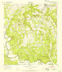
 1947 McMillan Mountains1953 Print · USGSCentral Texas hills and military expansion meet in the late 1940s near the Bell and Coryell county line. Researchers can trace family landmarks like Mayberry Cem and the Willow Springs Sch against the rising presence of the Fort Hood Military Reservation.
 - 1947 Map of Twin Moutains, 1953 Print
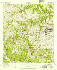
 1947 Twin Moutains1953 Print · USGSCoryell County is captured here in the late 1940s, as military expansion and railway transport defined the central Texas landscape. Researchers can trace family sites like Gotcher Cem and the early footprint of Copperas Cove alongside the Gulf Colorado and Santa Fe line.
 - 1947 Map of Copperas Cove, 1953 Print
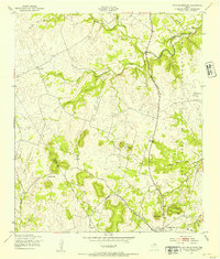
 1947 Copperas Cove1953 Print · USGSCopperas Cove and Kempner are shown in the late 1940s as rural centers alongside the growing military presence at Fort Hood. Genealogists can locate family sites at Starkie Cem and Smith Cem or trace the early course of the Lampasas River.
End of results
Showing maps 1-4 of 4
Top cities near Copperas Cove
Frequently asked questions
- What are the different types of historical maps available for Copperas Cove?
- What is the oldest map of Copperas Cove?
- Where can I purchase historical maps of Copperas Cove for my home or office?
- Where can I download high-res historical maps of Copperas Cove?
- Are there historical topographic maps available for Copperas Cove?
- Is there historical aerial imagery available for Copperas Cove?
- Where are historical maps of Copperas Cove sourced from?