1990s Maps of Copperas Cove, Texas
Explore 3 historic maps of Copperas Cove from the 1990s. These maps offer a rare glimpse into what life looked like during the 1990s — showing old roads, neighborhoods, homes, and landmarks that have changed or disappeared over time.
Whether you're researching your family's past, planning a metal detecting trip, or studying how Copperas Cove's landscape evolved across the 1990s, these high-resolution maps are a powerful tool for exploring the history of this region.
- Focus on a specific era: All maps on this page are from the 1990s, giving you a focused view of this time period.
- See what’s changed: Compare century-old streets, trails, and buildings to today's modern landscape using overlays and satellite layers.
- Research with precision: Use these maps for genealogy, historical research, land use analysis, or educational projects.
- View, download, or print: Maps are fully viewable online in high resolution, and can be downloaded or printed for your own records.
Start exploring Copperas Cove's history through authentic maps from the 1990s. This is your window into the past.
Copperas Cove, TX maps
(3)- 1994 Map of McMillan Mountains
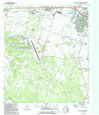 1994 McMillan Mountains1994 Print · USGSCentral Texas in the early nineties shows the expansion of Killeen alongside the Fort Hood Military Reservation. Researchers can locate several family burial grounds like Mayberry Cem and Sibley Cem, or trace landmarks like Crossville Mountain and Montague Village.
 - 1995 Map of Twin Mountains
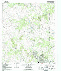 1995 Twin Mountains1995 Print · USGSThe rapid expansion of Copperas Cove meets the eastern boundary of the Fort Hood Military Reservation in the mid-nineties. Researchers can locate local landmarks like the Twin Mountains Cem, Lovel Ledger Sch, and family-named features like Herzog Mountain.
 - 1995 Map of Copperas Cove
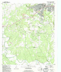 1995 Copperas Cove1995 Print · USGSCopperas Cove and Kempner are captured in the mid-1990s as suburban development meets the sprawling ranch lands of central Texas. Genealogists can trace long-standing family ties through sites like Kempner Cem, Ethridge Cem, and Oak Hills Ch.
End of results
Showing maps 1-3 of 3
Top cities near Copperas Cove
Frequently asked questions
- What are the different types of historical maps available for Copperas Cove?
- What is the oldest map of Copperas Cove?
- Where can I purchase historical maps of Copperas Cove for my home or office?
- Where can I download high-res historical maps of Copperas Cove?
- Are there historical topographic maps available for Copperas Cove?
- Is there historical aerial imagery available for Copperas Cove?
- Where are historical maps of Copperas Cove sourced from?