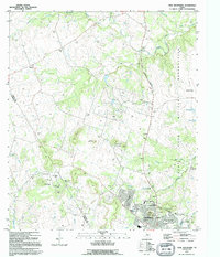
1995 Map of Twin Mountains
USGS Topo · Published 1995About this map
The growing urban footprint of Copperas Cove contrasts with the surrounding agricultural and military landscapes at the edge of the Coryell and Lampasas county line. The map highlights the city's residential expansion alongside essential community infrastructure such as the Halstead Sch, Lovel Ledger Sch, and the Copperas Cove City Park. To the east and north, the vast Fort Hood Military Reservation defines the land use, marked by a network of tank trails and military boundaries that separate the base from civilian life.
Find a feature on this map
38 named features on this map. Tap any name to fly to it.
Don’t see what you’re looking for? This feature index may not catch every label — zoom into the map to look around manually.
Map Details
Editions of this 1995 Twin Mountains Map
This is the sole edition of this map. No revisions or reprints were ever made.
Other maps of this area

1887 · Lampasas
USGS Topo · 1:125,000

1894 · Lampasas
USGS Topo · 1:125,000

1894 · Gatesville
USGS Topo · 1:125,000

1947 · Fort Hood
USGS Topo · 1:62,500

1947 · Fort Hood
USGS Topo · 1:24,000

1947 · Purmela
USGS Topo · 1:62,500

1947 · McMillan Mountains
USGS Topo · 1:24,000

1947 · Pidcoke
USGS Topo · 1:24,000

1947 · Shell Mountains
USGS Topo · 1:24,000

1947 · Twin Moutains
USGS Topo · 1:24,000