1960s Maps of Denton County, Texas
Explore 25 historic maps of Denton County from the 1960s. These maps offer a rare glimpse into what life looked like during the 1960s — showing old roads, neighborhoods, homes, and landmarks that have changed or disappeared over time.
Whether you're researching your family's past, planning a metal detecting trip, or studying how Denton County's landscape evolved across the 1960s, these high-resolution maps are a powerful tool for exploring the history of this region.
- Focus on a specific era: All maps on this page are from the 1960s, giving you a focused view of this time period.
- See what’s changed: Compare century-old streets, trails, and buildings to today's modern landscape using overlays and satellite layers.
- Research with precision: Use these maps for genealogy, historical research, land use analysis, or educational projects.
- View, download, or print: Maps are fully viewable online in high resolution, and can be downloaded or printed for your own records.
Start exploring Denton County's history through authentic maps from the 1960s. This is your window into the past.
Denton County, TX maps
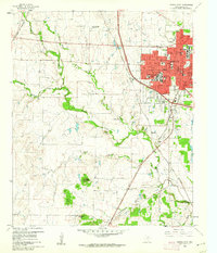
(25)- 1960 Map of Frisco, 1961 Print
 1960 Frisco1961 Print · USGSThe rural landscape of Collin County appears here just as the post-war era began to shape North Texas. Researchers can trace the early rail-side footprints of Frisco and Prosper, or locate family landmarks like Bethel Cem and the Rockhill Sch.5 unique versions available
 - 1960 Map of Justin, 1961 Print
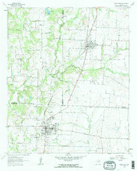
 1960 Justin1961 Print · USGSDenton County at the start of the 1960s shows a landscape of established rail towns and emerging reservoirs. Genealogists and local historians can trace the Elizabethtown (Site), locate the Odd Fellows Cem, and see the early footprint of the Grapevine Reservoir.4 unique versions available
 - 1960 Map of Sanger, 1961 Print
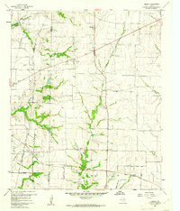
 1960 Sanger1961 Print · USGSSanger and Krum are shown here in the early 1960s, linked by the Gulf Colorado and Santa Fe railway during a period of steady growth. Genealogists can trace family sites at Bolivar Cem and Duck Creek Cem or locate the old Bolivar Oil Field.4 unique versions available
 - 1960 Map of Green Valley, 1961 Print
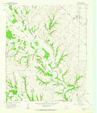
 1960 Green Valley1961 Print · USGSDenton County at the start of the sixties reveals a landscape shaped by the Elm Fork of the Trinity River and the rising Garza-Little Elm Reservoir. Genealogists and historians can trace rural landmarks including Rock Hill Ch, Davis Cem, and the tracks of the Texas and Pacific railroad.4 unique versions available
 - 1960 Map of Celina, 1961 Print
 1960 Celina1961 Print · USGSCollin and Denton counties come alive in the early sixties, showing a landscape shaped by the Frisco railroad. Genealogists can trace family footprints at Old Celina Cem, Old Union Cem, and the settlement of Alla.3 unique versions available
 - 1960 Map of Bluett, 1961 Print
 1960 Bluett1961 Print · USGSNorthern Texas ranching and farming lands are captured here in the early sixties along the Wise-Denton county line. Genealogists can locate rural landmarks like Corinth Ch and the small settlement of Bluett near the waters of Morris Branch.3 unique versions available
 - 1960 Map of Argyle, 1961 Print
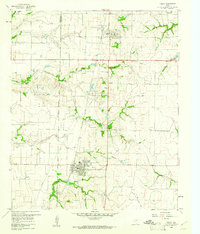
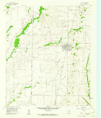
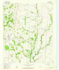
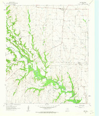
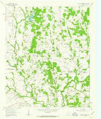
 1960 Argyle1961 Print · USGSDenton County at the dawn of the 1960s shows a landscape transformed by the newly formed Grapevine Reservoir. Genealogists and historians can trace the early footprints of Argyle and Roanoke, locate the Double Oak Sch, or find industrial roots at the local Strip Mine.5 unique versions available
 - 1960 Map of Rhome, 1961 Print
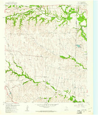
 1960 Rhome1961 Print · USGSWise County cattle country and rail junctions are documented here at the start of the sixties. You can trace the path of the FORT WORTH AND DENVER through Rhome or locate family sites like Fairview Ch and Aurora Cem.3 unique versions available
 - 1960 Map of Aubrey, 1962 Print
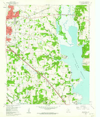
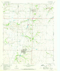
 1960 Aubrey1962 Print · USGSDenton County agricultural life is captured here in the early sixties, just as the Garza-Little Elm Reservoir began to reshape the local geography. Researchers can pinpoint the Belew Cem, the central Aubrey townsite, and rural landmarks like the Community House.2 unique versions available
 - 1960 Map of Lewisville East, 1962 Print
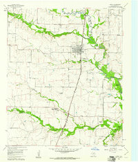
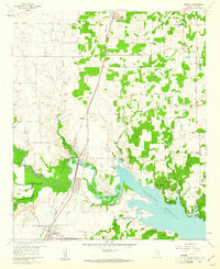
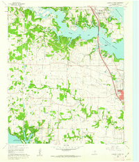
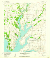
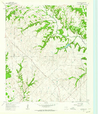
 1960 Lewisville East1962 Print · USGSDenton County at the start of the 1960s shows a landscape transformed by the Garza-Little Elm Reservoir and heavy rail. Local historians can trace old settlements like Midway and Round Grove alongside Ritter Cem and the Lewisville Hatchery.5 unique versions available
 - 1960 Map of Hebron, 1962 Print
 1960 Hebron1962 Print · USGSBefore the suburban sprawl of the late twentieth century, the borderlands of Denton and Collin County remained a landscape of rural schoolhouses and family cemeteries. Trace the early footprints of Hebron and Shepton or locate landmarks like Baccus Cem and the Liberty Ch.6 unique versions available
 - 1960 Map of Lewisville West, 1962 Print
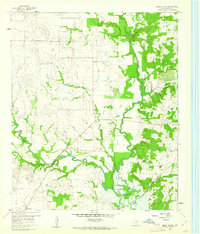
 1960 Lewisville West1962 Print · USGSDenton County at the start of the sixties reveals a landscape shaped by large-scale water projects and rural community life. Genealogists and local historians can trace family landmarks like Chinn Cem, Old Hall Cem, and Chinn Chapel across the rolling terrain.6 unique versions available
 - 1960 Map of Denton East, 1962 Print
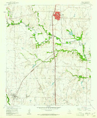
 1960 Denton East1962 Print · USGSDenton County in the early sixties captures a transition from college-town growth to the lakeside developments of Lake Dallas. Genealogists can trace family names at Oakwood Cem and Swisher Cem, or locate the historic Old Alton Ch.5 unique versions available
 - 1960 Map of Little Elm, 1962 Print
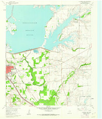
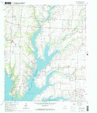
 1960 Little Elm1962 Print · USGSDenton County was in the midst of a transformation at the start of the sixties as the Garza-Little Elm Reservoir reshaped the land. Researchers can trace family history at Little Elm Cemetery or locate landmarks like Mary Young Chapel and the small community of Navo.2 unique versions available
 - 1960 Map of Denton West, 1962 Print
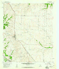
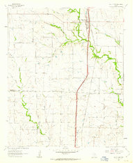
 1960 Denton West1962 Print · USGSDenton's western edge in the early sixties showcases a growing university town bounded by rural research stations and sprawling cattle country. Researchers can trace the mid-century footprints of North Texas State College or locate the IOOF Cem and Roselawn Memorial Cem.4 unique versions available
 - 1961 Map of Pilot Point, 1963 Print
 1961 Pilot Point1963 Print · USGSDenton and Grayson Counties are seen here in the early sixties, centered on the railroad corridor through the Texas prairie. Local historians can trace the foundations of Tioga and Pilot Point, locating sites like Gee High Sch, the Masonic Cem, and Tipton Chapel.3 unique versions available
 - 1961 Map of Era, 1963 Print
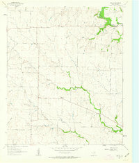
 1961 Era1963 Print · USGSThe border of Cooke and Denton counties is captured here in the early sixties as a landscape of rural cemeteries and active oil fields. Genealogists and historians can locate Cogburn Cem, the ridge of The Backbone, and the crossroads at Era.2 unique versions available
 - 1961 Map of Marilee, 1963 Print
 1961 Marilee1963 Print · USGSThe rural borderlands of Grayson, Denton, and Collin counties come into focus in the early sixties as the railroad era meets modern infrastructure. Trace the tracks of the St Louis San Francisco and Texas rail line through Marilee or locate local landmarks like Mt Carmel Ch and Gunter Cem.2 unique versions available
 - 1961 Map of Slidell, 1963 Print
 1961 Slidell1963 Print · USGSSlidell and the surrounding North Texas prairie are captured in the early sixties, as the region maintained its traditional agricultural character. Genealogists and researchers can trace family landmarks like Greenwood Cem and old settlements such as Sycamore and Allison.3 unique versions available
 - 1961 Map of Era SE, 1963 Print
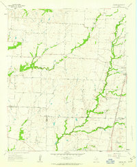
 1961 Era SE1963 Print · USGSThe rural expanse of Denton County in the early sixties is defined here by the winding drainages of the Hickory Creek watershed. Researchers can trace the layout of the Plainview settlement and explore the early footprint of the Bolivar Oil Field and its Oil Wells.2 unique versions available
 - 1961 Map of Mountain Springs, 1963 Print
 1961 Mountain Springs1963 Print · USGSCooke and Denton counties come into focus during the early sixties, showing a landscape of rural communities and rising oil production. Genealogists can locate several family cemeteries like Jones Cem and Tyson Cem or trace the early footprint of the Jacobs Oil Field.3 unique versions available
 - 1961 Map of Valley View, 1963 Print
 1961 Valley View1963 Print · USGSNorth Texas ranching and rail history come alive in this early 1960s survey of the Cooke and Denton county line. Trace the steam-era path of the Gulf Colorado and Santa Fe through Valley View and locate the quiet settlement of Lois.2 unique versions available
 - 1961 Map of Greenwood, 1964 Print
 1961 Greenwood1964 Print · USGSThe rural landscape of Wise County in the early sixties is detailed here, showing a network of small settlements and creek-side farms. Genealogists can trace family roots at Beasley Cem and visit the community centers at Greenwood and Dixon Creek Church.2 unique versions available
 - 1969 Map of Frisco
 1969 Frisco1969 Print · USGSThe North Texas prairie comes into focus during the late sixties as the rail-driven towns of Frisco and Prosper begin to grow. Genealogists can locate family burial sites like Bethel Cem and Landrum Cem nestled among traditional farm fields.
 - 1969 Map of Little Elm
 1969 Little Elm1969 Print · USGSThe Denton County countryside undergoes a major transformation in the late sixties as reservoir waters reshape the landscape. Genealogists and historians can trace family plots at Little Elm Cem and Lloyd Cem or locate old community centers like Navo.
End of results
Showing maps 1-25 of 25
Top cities of Denton County
- Denton historical maps
- Lewisville historical maps
- Flower Mound historical maps
- Little Elm historical maps
- The Colony historical maps
- Corinth historical maps
See more
Frequently asked questions
- What are the different types of historical maps available for Denton County?
- What is the oldest map of Denton County?
- Where can I purchase historical maps of Denton County for my home or office?
- Where can I download high-res historical maps of Denton County?
- Are there historical topographic maps available for Denton County?
- Is there historical aerial imagery available for Denton County?
- Where are historical maps of Denton County sourced from?