1960s Maps of Lewisville, Texas
Explore 3 historic maps of Lewisville from the 1960s. These maps offer a rare glimpse into what life looked like during the 1960s — showing old roads, neighborhoods, homes, and landmarks that have changed or disappeared over time.
Whether you're researching your family's past, planning a metal detecting trip, or studying how Lewisville's landscape evolved across the 1960s, these high-resolution maps are a powerful tool for exploring the history of this region.
- Focus on a specific era: All maps on this page are from the 1960s, giving you a focused view of this time period.
- See what’s changed: Compare century-old streets, trails, and buildings to today's modern landscape using overlays and satellite layers.
- Research with precision: Use these maps for genealogy, historical research, land use analysis, or educational projects.
- View, download, or print: Maps are fully viewable online in high resolution, and can be downloaded or printed for your own records.
Start exploring Lewisville's history through authentic maps from the 1960s. This is your window into the past.
Lewisville, TX maps
(3)- 1960 Map of Lewisville East, 1962 Print
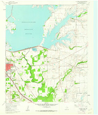 1960 Lewisville East1962 Print · USGSDenton County at the start of the 1960s shows a landscape transformed by the Garza-Little Elm Reservoir and heavy rail. Local historians can trace old settlements like Midway and Round Grove alongside Ritter Cem and the Lewisville Hatchery.5 unique versions available
 - 1960 Map of Hebron, 1962 Print
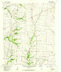 1960 Hebron1962 Print · USGSBefore the suburban sprawl of the late twentieth century, the borderlands of Denton and Collin County remained a landscape of rural schoolhouses and family cemeteries. Trace the early footprints of Hebron and Shepton or locate landmarks like Baccus Cem and the Liberty Ch.6 unique versions available
 - 1960 Map of Lewisville West, 1962 Print
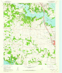 1960 Lewisville West1962 Print · USGSDenton County at the start of the sixties reveals a landscape shaped by large-scale water projects and rural community life. Genealogists and local historians can trace family landmarks like Chinn Cem, Old Hall Cem, and Chinn Chapel across the rolling terrain.6 unique versions available
End of results
Showing maps 1-3 of 3
Top cities near Lewisville
- Dallas historical maps
- Fort Worth historical maps
- Plano historical maps
- Irving historical maps
- Frisco historical maps
- McKinney historical maps
See more
Top neighborhoods of Lewisville
- Reserve at Timber Creek historical maps
- Vista Villas historical maps
- Britian Estates historical maps
- Hedrick Estates historical maps
- Normandy Homes historical maps
- Oak Creek Estates historical maps
See more
Frequently asked questions
- What are the different types of historical maps available for Lewisville?
- What is the oldest map of Lewisville?
- Where can I purchase historical maps of Lewisville for my home or office?
- Where can I download high-res historical maps of Lewisville?
- Are there historical topographic maps available for Lewisville?
- Is there historical aerial imagery available for Lewisville?
- Where are historical maps of Lewisville sourced from?