1960s Maps of Sanger, Texas
Explore 3 historic maps of Sanger from the 1960s. These maps offer a rare glimpse into what life looked like during the 1960s — showing old roads, neighborhoods, homes, and landmarks that have changed or disappeared over time.
Whether you're researching your family's past, planning a metal detecting trip, or studying how Sanger's landscape evolved across the 1960s, these high-resolution maps are a powerful tool for exploring the history of this region.
- Focus on a specific era: All maps on this page are from the 1960s, giving you a focused view of this time period.
- See what’s changed: Compare century-old streets, trails, and buildings to today's modern landscape using overlays and satellite layers.
- Research with precision: Use these maps for genealogy, historical research, land use analysis, or educational projects.
- View, download, or print: Maps are fully viewable online in high resolution, and can be downloaded or printed for your own records.
Start exploring Sanger's history through authentic maps from the 1960s. This is your window into the past.
Sanger, TX maps
(3)- 1960 Map of Sanger, 1961 Print
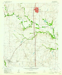 1960 Sanger1961 Print · USGSSanger and Krum are shown here in the early 1960s, linked by the Gulf Colorado and Santa Fe railway during a period of steady growth. Genealogists can trace family sites at Bolivar Cem and Duck Creek Cem or locate the old Bolivar Oil Field.4 unique versions available
 - 1960 Map of Green Valley, 1961 Print
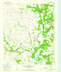 1960 Green Valley1961 Print · USGSDenton County at the start of the sixties reveals a landscape shaped by the Elm Fork of the Trinity River and the rising Garza-Little Elm Reservoir. Genealogists and historians can trace rural landmarks including Rock Hill Ch, Davis Cem, and the tracks of the Texas and Pacific railroad.4 unique versions available
 - 1961 Map of Valley View, 1963 Print
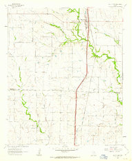 1961 Valley View1963 Print · USGSNorth Texas ranching and rail history come alive in this early 1960s survey of the Cooke and Denton county line. Trace the steam-era path of the Gulf Colorado and Santa Fe through Valley View and locate the quiet settlement of Lois.2 unique versions available
End of results
Showing maps 1-3 of 3
Top cities near Sanger
- Denton historical maps
- Little Elm historical maps
- Corinth historical maps
- Gainesville historical maps
- Providence Village historical maps
- Pilot Point historical maps
See more
Top neighborhoods of Sanger
Frequently asked questions
- What are the different types of historical maps available for Sanger?
- What is the oldest map of Sanger?
- Where can I purchase historical maps of Sanger for my home or office?
- Where can I download high-res historical maps of Sanger?
- Are there historical topographic maps available for Sanger?
- Is there historical aerial imagery available for Sanger?
- Where are historical maps of Sanger sourced from?