1960s Maps of Dickens, Texas
Explore 2 historic maps of Dickens from the 1960s. These maps offer a rare glimpse into what life looked like during the 1960s — showing old roads, neighborhoods, homes, and landmarks that have changed or disappeared over time.
Whether you're researching your family's past, planning a metal detecting trip, or studying how Dickens's landscape evolved across the 1960s, these high-resolution maps are a powerful tool for exploring the history of this region.
- Focus on a specific era: All maps on this page are from the 1960s, giving you a focused view of this time period.
- See what’s changed: Compare century-old streets, trails, and buildings to today's modern landscape using overlays and satellite layers.
- Research with precision: Use these maps for genealogy, historical research, land use analysis, or educational projects.
- View, download, or print: Maps are fully viewable online in high resolution, and can be downloaded or printed for your own records.
Start exploring Dickens's history through authentic maps from the 1960s. This is your window into the past.
Dickens, TX maps
(2)- 1967 Map of Dickens North, 1970 Print
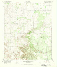 1967 Dickens North1970 Print · USGSThe broken country of West Texas comes into focus in the late sixties, showing the transition from the high plains to the canyonlands. Genealogists and local historians can trace family ties at Amity Cem or locate old landmarks like Elton, Dickens, and Mackenzie Peak.2 unique versions available
 - 1967 Map of Dickens South, 1970 Print
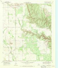 1967 Dickens South1970 Print · USGSDickens sits on the edge of the Caprock in the late 1960s, where the high plains meet the intricate erosional canyons of the Croton Breaks. Researchers can trace the local landscape through landmarks like Soldier Mound, the town Cem, and a mid-century Drive-in Theater.2 unique versions available
End of results
Showing maps 1-2 of 2
Top cities near Dickens
Frequently asked questions
- What are the different types of historical maps available for Dickens?
- What is the oldest map of Dickens?
- Where can I purchase historical maps of Dickens for my home or office?
- Where can I download high-res historical maps of Dickens?
- Are there historical topographic maps available for Dickens?
- Is there historical aerial imagery available for Dickens?
- Where are historical maps of Dickens sourced from?