
1967 Map of Dickens North
USGS Topo · Published 1970About this map
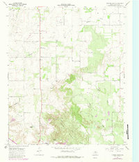
Croton Breaks dominate the southern landscape of this Dickens County quadrangle, where the terrain transitions into a labyrinth of canyons and sharp elevation changes. The settlement of Dickens sits at the southern edge, serving as a hub near the historical Dickens Spring and the local Roadside Park. To the north, the small community of Elton is positioned along the primary roadway, surrounded by a network of drainage features like Washout Creek and Little Boggy Creek. This late-1960s survey provides a clear view of the rural ranching and land-management patterns of the Texas Panhandle, evidenced by the fine red dashed lines indicating selected fence lines across the open country. Genealogists and local historians can locate specific landmarks such as Amity Cem and the prominent Mackenzie Peak, which stands as a landmark above the complex geography of Hobble Scobbie Canyon.
Find a feature on this map
16 named features on this map. Tap any name to fly to it.
Don’t see what you’re looking for? This feature index may not catch every label — zoom into the map to look around manually.
Map Details
Editions of this 1967 Dickens North Map
2 editions found
Other maps of this area

1954 · Lubbock
USGS Topo · 1:250,000

1967 · Dickens South
USGS Topo · 1:24,000

1967 · Haystack Mountain
USGS Topo · 1:24,000

1968 · East Afton
USGS Topo · 1:24,000

1968 · Foreman Chapel
USGS Topo · 1:24,000

1968 · Croton Camp
USGS Topo · 1:24,000

1968 · Rustler Camp
USGS Topo · 1:24,000

1968 · Sanders Hollow
USGS Topo · 1:24,000

1968 · Afton
USGS Topo · 1:24,000

1985 · Dickens
USGS Topo · 1:100,000