
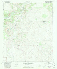
1968 Map of Sanders Hollow
USGS Topo · Published 1971About this map
The South Pease River and Tongue River converge in this corner of the Texas panhandle, shaping a landscape defined by deep draws and ranching infrastructure. Mapping by the U.S.G.S. in the late 1960s captures a sprawling network of water-management features essential to the local cattle industry, from Sanders Hollow Windmill and Jobe Windmill to the County Line Tank on the border between Motley and Dickens counties. The central Sanders Hollow drainage dominates the topography, leading toward the Red Lake Ranch and its associated Red Lake Ranch Airfield. This survey documents a specific moment in West Texas land use where family-named landmarks like Mark Windmill and Steve Windmill served as vital geographic markers across the prairie, alongside natural features like Darden Can and the North Wichita River.
Find a feature on this map
29 named features on this map. Tap any name to fly to it.
Don’t see what you’re looking for? This feature index may not catch every label — zoom into the map to look around manually.
Map Details
Editions of this 1968 Sanders Hollow Map
2 editions found
Other maps of this area

1954 · Lubbock
USGS Topo · 1:250,000

1967 · Dickens North
USGS Topo · 1:24,000

1968 · East Afton
USGS Topo · 1:24,000

1968 · Roaring Springs
USGS Topo · 1:24,000

1968 · Russellville
USGS Topo · 1:24,000

1968 · Dumont
USGS Topo · 1:24,000

1968 · China Canyon
USGS Topo · 1:24,000

1968 · East Afton NE
USGS Topo · 1:24,000

1968 · Afton
USGS Topo · 1:24,000

1985 · Dickens
USGS Topo · 1:100,000