
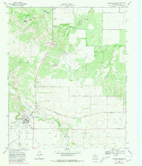
1968 Map of Roaring Springs
USGS Topo · Published 1970About this map
Roaring Springs serves as the focal point for this late-1960s survey of the Motley County landscape, situated at the edge of the Caprock Escarpment. The settlement pattern reflects a mid-century community tied to the Quanah Acme and Pacific railroad, which cuts across the terrain near the Roaring Springs Cemetery. Cultural markers of the era are evident in the presence of a Drive-in Theater and the Buzz Landing Field, highlighting local entertainment and aviation infrastructure during this period.
Find a feature on this map
20 named features on this map. Tap any name to fly to it.
Don’t see what you’re looking for? This feature index may not catch every label — zoom into the map to look around manually.
Map Details
Editions of this 1968 Roaring Springs Map
2 editions found
Other maps of this area

1954 · Lubbock
USGS Topo · 1:250,000

1954 · Plainview
USGS Topo · 1:250,000

1958 · Plainview
USGS Topo · 1:250,000

1966 · Matador
USGS Topo · 1:24,000

1966 · Ballard Camp
USGS Topo · 1:24,000

1967 · Whiteflat
USGS Topo · 1:24,000

1968 · Mac Bain
USGS Topo · 1:24,000

1968 · Russellville
USGS Topo · 1:24,000

1968 · Rustler Camp
USGS Topo · 1:24,000

1968 · Sanders Hollow
USGS Topo · 1:24,000