
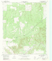
1968 Map of Russellville
USGS Topo · Published 1970About this map
The confluence of the South Pease River and the Tongue River anchors the southern portion of this Motley County landscape. During the late 1960s, this area maintained a distinctly rural character defined by ranching and the transit corridor of the Quanah Acme and Pacific railroad. The small settlement of Russellville and the nearby Russellville Camp serve as primary points of interest for local historians, while the Bird Ranch and scattered oil wells indicate the region's economic activities. The terrain is marked by significant drainages including Tee Pee Creek and Hackberry Creek, which carve through the plains. Traces of early 20th-century commerce are visible at Acme and Darden, providing a clear record of the settlement patterns and infrastructure supporting this remote part of the Texas Rolling Plains before modern consolidation altered many such communities.
Find a feature on this map
13 named features on this map. Tap any name to fly to it.
Don’t see what you’re looking for? This feature index may not catch every label — zoom into the map to look around manually.
Map Details
Editions of this 1968 Russellville Map
2 editions found
Other maps of this area

1954 · Lubbock
USGS Topo · 1:250,000

1954 · Plainview
USGS Topo · 1:250,000

1958 · Plainview
USGS Topo · 1:250,000

1966 · Matador
USGS Topo · 1:24,000

1966 · Ballard Camp
USGS Topo · 1:24,000

1966 · Tee Pee City
USGS Topo · 1:24,000

1968 · Roaring Springs
USGS Topo · 1:24,000

1968 · Dumont
USGS Topo · 1:24,000

1968 · China Canyon
USGS Topo · 1:24,000

1968 · Sanders Hollow
USGS Topo · 1:24,000