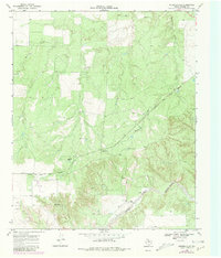
1968 Map of Russellville
USGS Topo · Published 1981About this map
Quanah Acme and Pacific tracks through the rugged terrain of Motley County, following a corridor that supported the regional cattle and transport economy during the mid-20th century. The landscape is defined by the winding course of the Tongue River (South Pease) and the intricate drainage systems of Tee Pee Creek and Hackberry Creek. Small rural clusters such as Russellville and Russellville Camp provide a look at the dispersed settlement patterns common in this part of Texas. Evidence of early resource extraction appears with scattered Oil Well sites, while localized landmarks like Bird Ranch, Darden, and Acme anchor the map’s human geography. This 1968 survey, revised in 1979, captures the area’s transition from a rail-dependent frontier to a modern ranching and energy-producing landscape.
Find a feature on this map
12 named features on this map. Tap any name to fly to it.
Don’t see what you’re looking for? This feature index may not catch every label — zoom into the map to look around manually.
Map Details
Editions of this 1968 Russellville Map
2 editions found
Other maps of this area

1954 · Lubbock
USGS Topo · 1:250,000

1954 · Plainview
USGS Topo · 1:250,000

1958 · Plainview
USGS Topo · 1:250,000

1966 · Matador
USGS Topo · 1:24,000

1966 · Ballard Camp
USGS Topo · 1:24,000

1966 · Tee Pee City
USGS Topo · 1:24,000

1968 · Roaring Springs
USGS Topo · 1:24,000

1968 · Russellville
USGS Topo · 1:24,000

1968 · Dumont
USGS Topo · 1:24,000

1968 · China Canyon
USGS Topo · 1:24,000