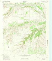
1967 Map of Hornica Creek
USGS Topo · Published 1981About this map
The North Pease River dominates the northern boundary of this Texas panhandle landscape, where the confluence with Quitaque Creek marks a significant hydrological junction. The terrain transition is defined by the sharp incisions of Arroyo Red and the deep cut of Walker Canyon, illustrating the erosional character of the Rolling Plains. Resource management in this arid environment is evident through a network of water-lifting infrastructure, including the Walker Canyon Windmill and the Dugout Windmill.
Find a feature on this map
12 named features on this map. Tap any name to fly to it.
Don’t see what you’re looking for? This feature index may not catch every label — zoom into the map to look around manually.
Map Details
Editions of this 1967 Hornica Creek Map
2 editions found
Other maps of this area

1954 · Plainview
USGS Topo · 1:250,000

1958 · Plainview
USGS Topo · 1:250,000

1966 · Matador
USGS Topo · 1:24,000

1966 · Ballard Camp
USGS Topo · 1:24,000

1967 · North Windmill
USGS Topo · 1:24,000

1967 · Cottonwood Camp
USGS Topo · 1:24,000

1967 · Hornica Creek
USGS Topo · 1:24,000

1967 · Turtle Hole Camp
USGS Topo · 1:24,000

1967 · Flomot
USGS Topo · 1:24,000

1967 · Whiteflat
USGS Topo · 1:24,000