
1967 Map of Hornica Creek
USGS Topo · Published 1969About this map
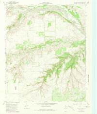
The North Pease River and Quitaque Creek converge in this section of the Texas Panhandle, carving deep drainage patterns through the Motley County ranchlands. Mapped by the Geological Survey and the Texas Water Development Board in the late 1960s, the landscape is defined by its water management and agricultural infrastructure. Numerous wells and specialized landmarks like the Walker Canyon Windmill and Dugout Windmill indicate the vital role of groundwater for local operations. The terrain is dramatically bisected by Walker Canyon, where steep contours contrast with the flatter upland plains. Notable hydrological features include Tom Ball Creek, Arroyo Red, and Hornica Creek, which snake through the territory toward the river. An industrial footprint is visible through the presence of a Gravel Pit and a major Pipeline corridor that cuts across the southern portion of the quadrangle.
Find a feature on this map
11 named features on this map. Tap any name to fly to it.
Don’t see what you’re looking for? This feature index may not catch every label — zoom into the map to look around manually.
Map Details
Editions of this 1967 Hornica Creek Map
2 editions found
Other maps of this area

1954 · Plainview
USGS Topo · 1:250,000

1958 · Plainview
USGS Topo · 1:250,000

1966 · Matador
USGS Topo · 1:24,000

1966 · Ballard Camp
USGS Topo · 1:24,000

1967 · North Windmill
USGS Topo · 1:24,000

1967 · Cottonwood Camp
USGS Topo · 1:24,000

1967 · Turtle Hole Camp
USGS Topo · 1:24,000

1967 · Flomot
USGS Topo · 1:24,000

1967 · Whiteflat
USGS Topo · 1:24,000
1967 · Folley
USGS Topo · 1:24,000