1900s (20th Century) Maps of Spur, Texas
Explore 4 historic maps of Spur from the 1900s (20th Century). These maps offer a rare glimpse into what life looked like during the 1900s — showing old roads, neighborhoods, homes, and landmarks that have changed or disappeared over time.
Whether you're researching your family's past, planning a metal detecting trip, or studying how Spur's landscape evolved across the 1900s, these high-resolution maps are a powerful tool for exploring the history of this region.
- Focus on a specific era: All maps on this page are from the 1900s, giving you a focused view of this time period.
- See what’s changed: Compare century-old streets, trails, and buildings to today's modern landscape using overlays and satellite layers.
- Research with precision: Use these maps for genealogy, historical research, land use analysis, or educational projects.
- View, download, or print: Maps are fully viewable online in high resolution, and can be downloaded or printed for your own records.
Start exploring Spur's history through authentic maps from the 1900s. This is your window into the past.
Spur, TX maps
(4)- 1954 Map of Lubbock, 1958 Print
 1954 Lubbock1958 Print · USGSThe High Plains and Caprock region of West Texas come alive in the mid-1950s, showing a landscape defined by oil discovery and the Brazos River headwaters. Genealogists and historians can trace rail-connected towns like Roaring Springs, find the Pleasant Valley church, or locate family-named landmarks such as Soldier Mound.4 unique versions available
 - 1967 Map of Spur, 1970 Print
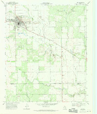 1967 Spur1970 Print · USGSSpur was a thriving West Texas hub in the late 1960s, showing its fully developed town grid and infrastructure. Researchers can trace local landmarks like Swenson Park, the town Cem, and the path of the Aqueduct crossing Spade Draw.
 - 1967 Map of Spur NW, 1971 Print
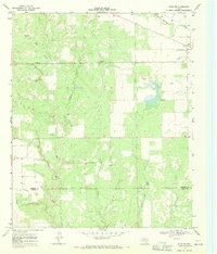 1967 Spur NW1971 Print · USGSThe West Texas landscape at the Dickens and Kent County line reveals a sophisticated network of 1960s water infrastructure. Researchers can trace the path of an AQUEDUCT near the Rolling Plains Research Station and locate landmarks like Red Mud Creek.
 - 1985 Map of Aspermont, 1994 Print
 1985 Aspermont1994 Print · USGSStonewall and Kent counties are shown in the mid-1980s as the river-cut plains of West Texas supported scattered ranching and oil communities. Genealogists and historians can trace the Railroad Grade and locate smaller locales like Old Glory and Girard.
End of results
Showing maps 1-4 of 4
Top cities near Spur
Frequently asked questions
- What are the different types of historical maps available for Spur?
- What is the oldest map of Spur?
- Where can I purchase historical maps of Spur for my home or office?
- Where can I download high-res historical maps of Spur?
- Are there historical topographic maps available for Spur?
- Is there historical aerial imagery available for Spur?
- Where are historical maps of Spur sourced from?