1980s Maps of Asherton, Texas
Explore 2 historic maps of Asherton from the 1980s. These maps offer a rare glimpse into what life looked like during the 1980s — showing old roads, neighborhoods, homes, and landmarks that have changed or disappeared over time.
Whether you're researching your family's past, planning a metal detecting trip, or studying how Asherton's landscape evolved across the 1980s, these high-resolution maps are a powerful tool for exploring the history of this region.
- Focus on a specific era: All maps on this page are from the 1980s, giving you a focused view of this time period.
- See what’s changed: Compare century-old streets, trails, and buildings to today's modern landscape using overlays and satellite layers.
- Research with precision: Use these maps for genealogy, historical research, land use analysis, or educational projects.
- View, download, or print: Maps are fully viewable online in high resolution, and can be downloaded or printed for your own records.
Start exploring Asherton's history through authentic maps from the 1980s. This is your window into the past.
Asherton, TX maps
(2)- 1982 Map of Asherton
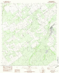 1982 Asherton1982 Print · USGSAsherton was an established South Texas hub in the early eighties, surrounded by a complex network of seasonal creek beds. Researchers can trace the local infrastructure of the era, from the town grid to the Landing Strip and Carrizo Creek drainage.
 - 1985 Map of Cotulla
 1985 Cotulla1985 Print · USGSSouth Texas ranching country in the mid-1980s is captured here at a 1:100,000 scale. Genealogists and historians can trace the Missouri Pacific line through Cotulla and Artesia Wells, or locate remote points along Pena Creek and an Old Railroad Grade.2 unique versions available
End of results
Showing maps 1-2 of 2
Top cities near Asherton
- Crystal City historical maps
- Carrizo Springs historical maps
- Big Wells historical maps
- Catarina historical maps
Frequently asked questions
- What are the different types of historical maps available for Asherton?
- What is the oldest map of Asherton?
- Where can I purchase historical maps of Asherton for my home or office?
- Where can I download high-res historical maps of Asherton?
- Are there historical topographic maps available for Asherton?
- Is there historical aerial imagery available for Asherton?
- Where are historical maps of Asherton sourced from?