1970s Maps of Ector County, Texas
Explore 3 historic maps of Ector County from the 1970s. These maps offer a rare glimpse into what life looked like during the 1970s — showing old roads, neighborhoods, homes, and landmarks that have changed or disappeared over time.
Whether you're researching your family's past, planning a metal detecting trip, or studying how Ector County's landscape evolved across the 1970s, these high-resolution maps are a powerful tool for exploring the history of this region.
- Focus on a specific era: All maps on this page are from the 1970s, giving you a focused view of this time period.
- See what’s changed: Compare century-old streets, trails, and buildings to today's modern landscape using overlays and satellite layers.
- Research with precision: Use these maps for genealogy, historical research, land use analysis, or educational projects.
- View, download, or print: Maps are fully viewable online in high resolution, and can be downloaded or printed for your own records.
Start exploring Ector County's history through authentic maps from the 1970s. This is your window into the past.
Ector County, TX maps
(3)- 1971 Map of Notrees, 1974 Print
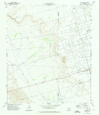 1971 Notrees1974 Print · USGSThe West Texas oil patch comes into sharp focus in the early seventies, centered on the small crossroads of Notrees. Researchers can trace the industrial footprint of the T X L Oil Field and map the expanse of Shifting Sand along the county line.
 - 1971 Map of Bedford Ranch, 1974 Print
 1971 Bedford Ranch1974 Print · USGSWinkler and Andrews counties come alive in the early seventies, where the cattle-ranching West meets the industrial Permian Basin. Trace the landscape of the Goldsmith Oil Field and And Ector Oil Field alongside local landmarks like Bedford Ranch and the Green Gate Windmill.
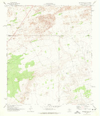
 - 1971 Map of Amburgey Ranch, 1974 Print
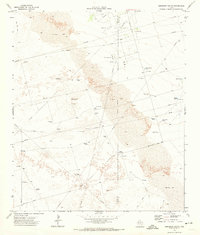 1971 Amburgey Ranch1974 Print · USGSThe West Texas ranchlands of Winkler and Ector Counties are captured here in the early 1970s as the local oil economy expanded across the dunes. Researchers can trace historic water sources and ranching sites like Amburgey Ranch, White Horse Tank, and Wheeler Windmill.
End of results
Showing maps 1-3 of 3
Top cities of Ector County
Frequently asked questions
- What are the different types of historical maps available for Ector County?
- What is the oldest map of Ector County?
- Where can I purchase historical maps of Ector County for my home or office?
- Where can I download high-res historical maps of Ector County?
- Are there historical topographic maps available for Ector County?
- Is there historical aerial imagery available for Ector County?
- Where are historical maps of Ector County sourced from?