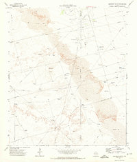
1971 Map of Amburgey Ranch
USGS Topo · Published 1974About this map
The Winkler Co Ector Co line bisects this Permian Basin landscape, where mid-century industrial infrastructure meets the shifting sands of West Texas. The Wheeler Oil Field dominates the northern reaches, characterized by a dense network of pipelines, Shell Wells, and a dedicated Pumping Station. Beyond the industrial activity, the map reveals a cattle-ranching geography defined by isolated water sources. Family and local landmarks such as Amburgey Ranch, Mitchell Windmill, and Wheeler Windmill provided essential points of orientation in a region of Shifting Sand. The reliance on artificial water storage is evident in features like White Horse Tank, Big Tanks, and Bumper Tank, which supported livestock across the arid terrain. Transportation in this era relied on straight-line routes like Blockline Road and numerous Jeep Trails that maneuver through the dunes.
Find a feature on this map
26 named features on this map. Tap any name to fly to it.
Don’t see what you’re looking for? This feature index may not catch every label — zoom into the map to look around manually.
Map Details
Editions of this 1971 Amburgey Ranch Map
This is the sole edition of this map. No revisions or reprints were ever made.
Other maps of this area

1954 · Pecos
USGS Topo · 1:250,000

1957 · Pecos
USGS Topo · 1:250,000

1964 · Turnbaugh Corner
USGS Topo · 1:24,000

1964 · Metz
USGS Topo · 1:24,000

1964 · Red Lakes
USGS Topo · 1:24,000

1968 · Cowden Place
USGS Topo · 1:24,000

1968 · China Ranch
USGS Topo · 1:24,000

1971 · Notrees
USGS Topo · 1:24,000

1971 · Notrees NW
USGS Topo · 1:24,000
1971 · Wheeler Ranch
USGS Topo · 1:24,000