1960s Maps of West Odessa, Texas
Explore 4 historic maps of West Odessa from the 1960s. These maps offer a rare glimpse into what life looked like during the 1960s — showing old roads, neighborhoods, homes, and landmarks that have changed or disappeared over time.
Whether you're researching your family's past, planning a metal detecting trip, or studying how West Odessa's landscape evolved across the 1960s, these high-resolution maps are a powerful tool for exploring the history of this region.
- Focus on a specific era: All maps on this page are from the 1960s, giving you a focused view of this time period.
- See what’s changed: Compare century-old streets, trails, and buildings to today's modern landscape using overlays and satellite layers.
- Research with precision: Use these maps for genealogy, historical research, land use analysis, or educational projects.
- View, download, or print: Maps are fully viewable online in high resolution, and can be downloaded or printed for your own records.
Start exploring West Odessa's history through authentic maps from the 1960s. This is your window into the past.
West Odessa, TX maps
(4)- 1964 Map of Odessa SW, 1966 Print
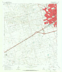 1964 Odessa SW1966 Print · USGSOdessa's midcentury expansion meets the booming oil fields of the Permian Basin in the 1960s. Genealogists and historians can trace the development of local neighborhoods through Odessa College, the Odessa Meteor Crater, and the industrial Carbon Black Plant.4 unique versions available
 - 1964 Map of Odessa NW, 1966 Print
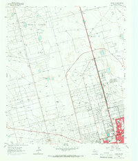 1964 Odessa NW1966 Print · USGSOdessa pushes into the Permian Basin during the mid-sixties oil boom, transforming the arid landscape into an industrial and suburban hub. Genealogists and historians can trace the growth of neighborhoods like Greenfield Acres or locate local landmarks including Goliad Sch and the Drive-in Theater.4 unique versions available
 - 1964 Map of Douro, 1967 Print
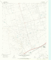 1964 Douro1967 Print · USGSEctor County oil country is shown in the 1960s as a complex network of extraction and rail transport. Genealogists and historians can trace Old Buchanan Ranch (Headquarters) and industrial sites like the Carbon Black Plant near Douro.3 unique versions available
 - 1965 Map of Goldsmith, 1967 Print
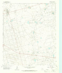 1965 Goldsmith1967 Print · USGSGoldsmith and the surrounding Ector County oil patches are shown at their mid-century peak during this 1960s survey. Researchers can trace the industrial landscape of the Goldsmith Oil Field and North Cowden Oil Field alongside local landmarks like Oil Camp and James Lake.3 unique versions available
End of results
Showing maps 1-4 of 4
Top cities near West Odessa
Top neighborhoods of West Odessa
- Cowden Oil Field historical maps
- West Odessa historical maps
- Ava Subdivision historical maps
- Frontier Park historical maps
- Chaparral historical maps
- West Concho Estates historical maps
See more
Frequently asked questions
- What are the different types of historical maps available for West Odessa?
- What is the oldest map of West Odessa?
- Where can I purchase historical maps of West Odessa for my home or office?
- Where can I download high-res historical maps of West Odessa?
- Are there historical topographic maps available for West Odessa?
- Is there historical aerial imagery available for West Odessa?
- Where are historical maps of West Odessa sourced from?