Old Maps of Ellis County, Texas for Hiking & Exploration
Hike through history with 160 historic maps of Ellis County. Explore old trails, ghost towns, and forgotten backroads — perfect for outdoor adventurers and local explorers.
- Rediscover forgotten places: Map out old mining camps, roads, and footpaths that no longer exist on modern maps.
- Layer with modern tools: Combine with LiDAR or satellite views to plan hikes through historical terrain.
- Made for exploration: Popular among hikers, overlanders, and local history lovers.
Use these maps to find adventure and explore the hidden past of Ellis County.
Ellis County, TX maps
(160)- 1891 Map of Dallas
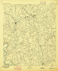
 1891 Dallas1891 Print · USGSThe Dallas area during the late nineteenth century was a rapidly growing rail hub still defined by its river crossings and rural outposts. Genealogists and historians can trace the foundations of the metroplex through early landmarks like Oak Cliff, Doddy's Ferry, and Haughts Store.
 - 1891 Map of Cleburne
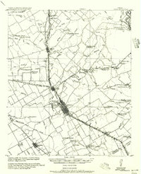
 1891 Cleburne1891 Print · USGSNorth Texas in the late nineteenth century was a land transformed by new iron rails and established river crossings. Genealogists and researchers can trace the early footprints of Cleburne and Hillsboro alongside vanished stops like Port Graham and Files Valley.
 - 1893 Map of Dallas
 1893 Dallas1893 Print · USGSDallas was a rising railroad power in the 1890s, when iron rails and river crossings dictated the growth of North Texas. Genealogists can locate vanished landmarks and rural hubs like Oak Cliff, Doddy's Ferry, and Haught's Store before the city's modern sprawl.5 unique versions available
 - 1894 Map of Cleburne
 1894 Cleburne1894 Print · USGSNorth Central Texas was a burgeoning rail and cattle hub in the late nineteenth century. Genealogists and historians can trace the growth of Cleburne and Hillsboro alongside vanished river landings like Fort Graham and Kimball on the Brazos River.5 unique versions available
 - 1894 Map of Fort Worth, 1918 Print
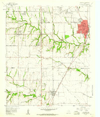
 1894 Fort Worth1918 Print · USGSNorth Texas at the end of the nineteenth century centers on a burgeoning Fort Worth and its strategic rail junctions. Researchers can locate early township sites like Johnson Station and Birdville or trace the military footprint of Camp Bowie.3 unique versions available
 - 1954 Map of Dallas, 1963 Print
 1954 Dallas1963 Print · USGSNorth Texas in the mid-fifties and early sixties reveals a landscape of rapid urban growth and water management. Genealogists and historians can trace the evolution of the metroplex through landmarks like Hensley Field, Boles Orphan Home, and the Texas & Pacific RR.4 unique versions available
 - 1956 Map of Ennis
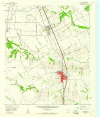
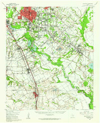
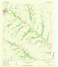
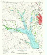
 1956 Ennis1956 Print · USGSEllis County agricultural life is captured here in the years following the first World War, centered on the rail crossroads at Ennis P.O. Genealogists can locate family landmarks like Ghost School, Antioch Church, and the settlement of Boyce (Cottonwood).
 - 1958 Map of Dallas
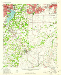
 1958 Dallas1958 Print · USGSNorth Texas in the late fifties shows the dramatic expansion of the Metroplex as it absorbs surrounding farm towns. Genealogists and historians can trace old rail lines like the Missouri-Kansas-Texas and locate early lakefront developments at Eagle Mountain Lake and Lake Worth Village.
 - 1959 Map of Lancaster, 1960 Print
 1959 Lancaster1960 Print · USGSSouthern Dallas County and northern Ellis County are shown here in the late fifties, as traditional farming communities began to expand. You can locate family history at Rawlins Cem, trace the Missouri Kansas Texas Railroad corridor, and find old landmarks like Camp Pinkston or Beckley City Chapel.5 unique versions available
 - 1959 Map of Cedar Hill, 1960 Print
 1959 Cedar Hill1960 Print · USGSDuring the late fifties, the Dallas and Ellis county line remained a mix of rural encampments and developing suburbs like Cedar Hill and De Soto. Researchers can trace old family sites at Rhodes Cemetery or find historic community hubs like Shiloh Cemetery and the True Vine Church.6 unique versions available
 - 1959 Map of Ferris, 1960 Print
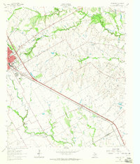
 1959 Ferris1960 Print · USGSThe northern Ellis County borderlands and southern Dallas County come alive in the late fifties, showing the rail-centered growth of Ferris and Wilmer. Researchers can trace old family sites near Bluff Springs Cemetery or the Dunbar High School.3 unique versions available
 - 1959 Map of India, 1960 Print
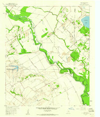 1959 India1960 Print · USGSThe Trinity River floodplain at the junction of Dallas, Ellis, and Kaufman Counties is shown here in the late fifties during a period of active rural industry. Genealogists can trace family landmarks like Pruitt Cem, Grange Hall, and the settlement of India.4 unique versions available
 - 1959 Map of Britton, 1960 Print
 1959 Britton1960 Print · USGSNorth Texas farm and rail country comes into focus in the late fifties at the junction of Tarrant, Dallas, and Ellis counties. Genealogists can trace family landmarks like Pleasant Valley Cem, St Paul Ch, and the rail junction at Britton.6 unique versions available
 - 1959 Map of Arlington, 1961 Print
 1959 Arlington1961 Print · USGSArlington and Mansfield are caught in a moment of post-war transformation as the suburbs of North Texas begin to bloom. Genealogists and local historians can trace family locations near Rehoboth Cem, study the footprint of Arlington State College, or locate vanished landmarks like Lucas Airport.
 - 1959 Map of Seagoville, 1962 Print
 1959 Seagoville1962 Print · USGSSoutheast of Dallas in the late fifties, the Trinity River valley served as a busy corridor of railroads and growing townships. Trace family roots at Sand Branch Cem, locate the Hutchins Boys Industrial Sch, and explore the winding Parsons Slough.
 - 1960 Map of Boz, 1963 Print
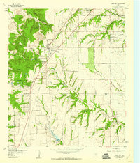
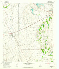
 1960 Boz1963 Print · USGSTexas cotton country in the early sixties centers on the rural community of Boz and its network of creek-side farmsteads. Genealogists and historians can locate family landmarks like Greathouse Cem, Spring Graves, and the Oak Branch Ch.4 unique versions available
 - 1961 Map of Maypearl, 1963 Print
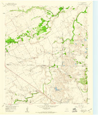
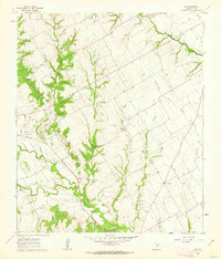
 1961 Maypearl1963 Print · USGSMaypearl and the Ellis County countryside are captured here in the early sixties, showing the agricultural landscape before suburban expansion. Genealogists can trace family landmarks and rural burial sites like Auburn Cem, Odom Cem, and the rail-side community of Griffith.3 unique versions available
 - 1961 Map of Forreston, 1963 Print
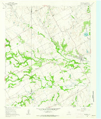
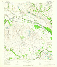
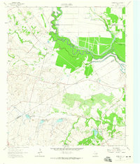
 1961 Forreston1963 Print · USGSEllis County in the early sixties showcases a rural landscape shaped by the new Lake Waxahachie and established rail lines. Genealogists and local historians can trace family locations near Reagor Springs, Glenwood Cem, and the old station at Forreston.2 unique versions available
 - 1961 Map of Midlothian, 1963 Print
 1961 Midlothian1963 Print · USGSMidlothian and the rural reaches of Ellis County are captured here in the early sixties, showing a landscape defined by rail lines and creek branches. Researchers can trace family sites like Singleton Farm or visit the Sardis Cem and Washington Sch.3 unique versions available
 - 1961 Map of Venus, 1963 Print
 1961 Venus1963 Print · USGSThe rail-driven growth of the Johnson and Ellis county line is captured here in the early sixties, centered on the junction at Venus. Researchers can trace old family landmarks and infrastructure including Newton Cem, Hopewell Ch, and the Southern Pacific line.4 unique versions available
 - 1961 Map of Waxahachie, 1963 Print
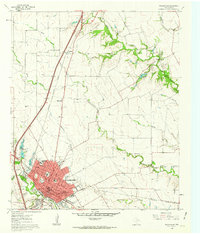 1961 Waxahachie1963 Print · USGSWaxahachie and its surrounding Ellis County farmlands are captured in the early sixties as the interstate era began to reshape the Texas landscape. Researchers can trace historic local institutions like the Southwestern Bible Institute, Bell Chapel Cem, and the Jack Coesie Childrens Home.3 unique versions available
 - 1962 Map of Emhouse, 1965 Print
 1962 Emhouse1965 Print · USGSNorth of Corsicana in the early sixties, the borderlands of Navarro and Ellis Counties supported a landscape of prairie creeks and busy rail lines. Trace family history near Emhouse, locate the Pattison Cem, and follow the path of the Rock Island and Pacific railroad.2 unique versions available
 - 1962 Map of Ennis West, 1965 Print
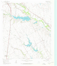
 1962 Ennis West1965 Print · USGSEllis County in the early sixties showcases the transformation of the landscape as the new reservoir reaches its pool elevation. Genealogists and local historians can trace family plots at Myrtle Cemetery or Bethel Cem and locate rail features like the Southern Pacific tracks.3 unique versions available
 - 1962 Map of Ennis East, 1965 Print
 1962 Ennis East1965 Print · USGSEastern Ellis County in the early 1960s shows a landscape of rail-linked prairie towns and country schools. Genealogists can trace family footprints at Redwine Cem, Alma, and the St Johns Ch.3 unique versions available
 - 1962 Map of Rosser SW, 1965 Print
 1962 Rosser SW1965 Print · USGSNavarro County in the early 1960s was a landscape of rural family farms and emerging water management systems along the Trinity River. Local researchers can locate Rice Cem, the Hopewell Ch, and several named reservoirs along Grays Creek.
Showing maps 1-25 of 160
Top cities of Ellis County
- Waxahachie historical maps
- Ennis historical maps
- Midlothian historical maps
- Ferris historical maps
- Palmer historical maps
- Italy historical maps
See more
Frequently asked questions
- What are the different types of historical maps available for Ellis County?
- What is the oldest map of Ellis County?
- Where can I purchase historical maps of Ellis County for my home or office?
- Where can I download high-res historical maps of Ellis County?
- Are there historical topographic maps available for Ellis County?
- Is there historical aerial imagery available for Ellis County?
- Where are historical maps of Ellis County sourced from?