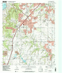
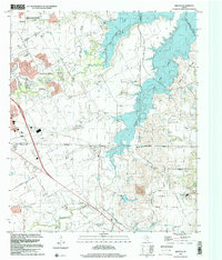
1900s (20th Century) Maps of Midlothian, Texas
Explore 13 historic maps of Midlothian from the 1900s (20th Century). These maps offer a rare glimpse into what life looked like during the 1900s — showing old roads, neighborhoods, homes, and landmarks that have changed or disappeared over time.
Whether you're researching your family's past, planning a metal detecting trip, or studying how Midlothian's landscape evolved across the 1900s, these high-resolution maps are a powerful tool for exploring the history of this region.
- Focus on a specific era: All maps on this page are from the 1900s, giving you a focused view of this time period.
- See what’s changed: Compare century-old streets, trails, and buildings to today's modern landscape using overlays and satellite layers.
- Research with precision: Use these maps for genealogy, historical research, land use analysis, or educational projects.
- View, download, or print: Maps are fully viewable online in high resolution, and can be downloaded or printed for your own records.
Start exploring Midlothian's history through authentic maps from the 1900s. This is your window into the past.
Midlothian, TX maps
(13)- 1954 Map of Dallas, 1963 Print
 1954 Dallas1963 Print · USGSNorth Texas in the mid-fifties and early sixties reveals a landscape of rapid urban growth and water management. Genealogists and historians can trace the evolution of the metroplex through landmarks like Hensley Field, Boles Orphan Home, and the Texas & Pacific RR.4 unique versions available
 - 1958 Map of Dallas
 1958 Dallas1958 Print · USGSNorth Texas in the late fifties shows the dramatic expansion of the Metroplex as it absorbs surrounding farm towns. Genealogists and historians can trace old rail lines like the Missouri-Kansas-Texas and locate early lakefront developments at Eagle Mountain Lake and Lake Worth Village.
 - 1959 Map of Cedar Hill, 1960 Print
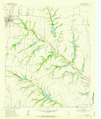
 1959 Cedar Hill1960 Print · USGSDuring the late fifties, the Dallas and Ellis county line remained a mix of rural encampments and developing suburbs like Cedar Hill and De Soto. Researchers can trace old family sites at Rhodes Cemetery or find historic community hubs like Shiloh Cemetery and the True Vine Church.6 unique versions available
 - 1959 Map of Britton, 1960 Print
 1959 Britton1960 Print · USGSNorth Texas farm and rail country comes into focus in the late fifties at the junction of Tarrant, Dallas, and Ellis counties. Genealogists can trace family landmarks like Pleasant Valley Cem, St Paul Ch, and the rail junction at Britton.6 unique versions available
 - 1959 Map of Arlington, 1961 Print
 1959 Arlington1961 Print · USGSArlington and Mansfield are caught in a moment of post-war transformation as the suburbs of North Texas begin to bloom. Genealogists and local historians can trace family locations near Rehoboth Cem, study the footprint of Arlington State College, or locate vanished landmarks like Lucas Airport.
 - 1961 Map of Midlothian, 1963 Print
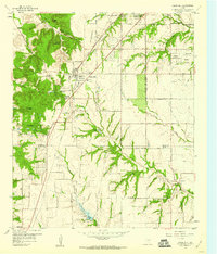
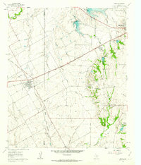
 1961 Midlothian1963 Print · USGSMidlothian and the rural reaches of Ellis County are captured here in the early sixties, showing a landscape defined by rail lines and creek branches. Researchers can trace family sites like Singleton Farm or visit the Sardis Cem and Washington Sch.3 unique versions available
 - 1961 Map of Venus, 1963 Print
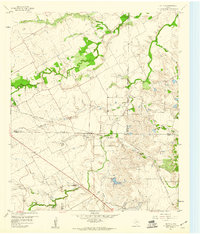
 1961 Venus1963 Print · USGSThe rail-driven growth of the Johnson and Ellis county line is captured here in the early sixties, centered on the junction at Venus. Researchers can trace old family landmarks and infrastructure including Newton Cem, Hopewell Ch, and the Southern Pacific line.4 unique versions available
 - 1985 Map of Fort Worth
 1985 Fort Worth1985 Print · USGSMid-1980s Tarrant County and Parker County emerge from a transition between urban sprawl and rural cattle country. Researchers can trace the expansion of Fort Worth and Arlington alongside older landmarks like Nebo Mtn and Kikapoo Falls.2 unique versions available
 - 1985 Map of Cleburne
 1985 Cleburne1985 Print · USGSThe Brazos River valley and its major mid-century reservoirs dominate this North Central Texas landscape during the 1980s. Local researchers can trace family roots through sites like Mt Carmel Ch, Oak Hill Sch, and the unique river bends near Glen Rose.2 unique versions available
 - 1985 Map of Corsicana, 1986 Print
 1985 Corsicana1986 Print · USGSNorth Central Texas was defined by its expanding water reservoirs and deep-rooted rail corridors in the mid-eighties. Researchers can trace the heritage of local communities through landmarks like Southwestern Bible Institute, Navarro College, and rural markers such as Derrs Chapel.2 unique versions available
 - 1986 Map of Dallas
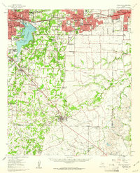
 1986 Dallas1986 Print · USGSThe North Texas metropolitan landscape comes into focus during the mid-eighties as urban growth expands toward the eastern reservoirs. Researchers can trace historic cemeteries like Oak Cliff Cem, rail corridors of the Texas & Pacific RR, and landmarks such as Southern Methodist University.3 unique versions available
 - 1995 Map of Cedar Hill, 2001 Print
 1995 Cedar Hill2001 Print · USGSThe suburban landscape south of Dallas was undergoing significant growth in the mid-nineties as cities like De Soto and Ovilla expanded. You can trace family roots at the Shiloh Cemetery or locate landmarks like the Mount Lebanon Encampment and Cedarview.
 - 1995 Map of Britton, 2002 Print
 1995 Britton2002 Print · USGSThe Tarrant and Dallas county borderlands were being rapidly transformed by the waters of Joe Pool Lake in the mid-1990s. Local researchers can still find historic landmarks like the Britton settlement, Estes Cem, and Friendship Ch amid the expanding suburbs.
End of results
Showing maps 1-13 of 13
Top cities near Midlothian
- Dallas historical maps
- Fort Worth historical maps
- Arlington historical maps
- Grand Prairie historical maps
- Mansfield historical maps
- DeSoto historical maps
See more
Top neighborhoods of Midlothian
- Ward historical maps
- Mockingbird Estates historical maps
- Park Place historical maps
- Windermere Estates historical maps
- Kensington Park historical maps
Frequently asked questions
- What are the different types of historical maps available for Midlothian?
- What is the oldest map of Midlothian?
- Where can I purchase historical maps of Midlothian for my home or office?
- Where can I download high-res historical maps of Midlothian?
- Are there historical topographic maps available for Midlothian?
- Is there historical aerial imagery available for Midlothian?
- Where are historical maps of Midlothian sourced from?