1950s Maps of Falls County, Texas
Explore 11 historic maps of Falls County from the 1950s. These maps offer a rare glimpse into what life looked like during the 1950s — showing old roads, neighborhoods, homes, and landmarks that have changed or disappeared over time.
Whether you're researching your family's past, planning a metal detecting trip, or studying how Falls County's landscape evolved across the 1950s, these high-resolution maps are a powerful tool for exploring the history of this region.
- Focus on a specific era: All maps on this page are from the 1950s, giving you a focused view of this time period.
- See what’s changed: Compare century-old streets, trails, and buildings to today's modern landscape using overlays and satellite layers.
- Research with precision: Use these maps for genealogy, historical research, land use analysis, or educational projects.
- View, download, or print: Maps are fully viewable online in high resolution, and can be downloaded or printed for your own records.
Start exploring Falls County's history through authentic maps from the 1950s. This is your window into the past.
Falls County, TX maps
(11)- 1954 Map of Waco, 1964 Print
 1954 Waco1964 Print · USGSCentral Texas during the mid-fifties shows a landscape defined by the expansion of Fort Hood Military Reservation and the Brazos river system. Trace the rail lines and early airfields like James Connally Air Force Base and settlements like Temple or McGregor.2 unique versions available
 - 1954 Map of Austin, 1964 Print
 1954 Austin1964 Print · USGSCentral Texas is captured during a period of steady growth as the capital city and its neighboring farm towns began to modernize. Researchers can trace historic rail corridors like the Southern Pacific RR or locate landmarks such as Bergstrom Air Force Base and Pilot Knob.4 unique versions available
 - 1955 Map of Waco
 1955 Waco1955 Print · USGSCentral Texas at the peak of the Cold War reveals a landscape defined by military expansion and major water projects. Researchers can trace the footprints of Fort Hood, the waters of Lake Waco, and regional hubs like Temple or Mexia.
 - 1956 Map of Mart, 1958 Print
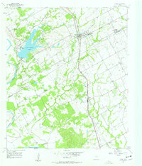
 1956 Mart1958 Print · USGSAgricultural life in McLennan County thrived in the mid-1950s as the town of Mart sat at the busy intersection of the Missouri Pacific rail line. Researchers can trace rural school locations like Anderson Sch and family burial sites at Evergreen Cem and Mart Cem.2 unique versions available
 - 1957 Map of Bruceville, 1958 Print
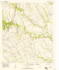 1957 Bruceville1958 Print · USGSThe Falls and McLennan County line in the late fifties shows a rural landscape shaped by the Missouri Kansas Texas rail line. Genealogists can trace family names through Beulah Cem, Mooreville Cem, and the Cottonwood Sch (Aband).4 unique versions available
 - 1957 Map of Otto, 1958 Print
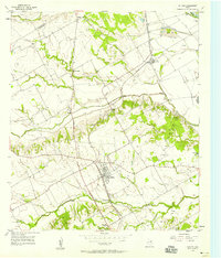
 1957 Otto1958 Print · USGSThe rural settlement of Otto and the surrounding Falls County countryside are captured here in the late fifties as family farms relied on the MISSOURI PACIFIC rail line. Researchers can locate many local landmarks including Metina Cem and the Corner Sch (Aband).
 - 1957 Map of McClanahan, 1958 Print
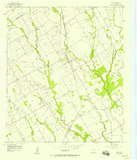
 1957 McClanahan1958 Print · USGSFalls County in the late 1950s is defined by its rural church communities and the dual rail lines serving the cotton and cattle country. Researchers can trace family sites like Taylor Chapel Cem, Marvin Allen Ch, and the small settlement of Mc Clanahan.2 unique versions available
 - 1957 Map of Riesel, 1958 Print
 1957 Riesel1958 Print · USGSCentral Texas farmland in the 1950s is captured here, centered on the rail-aligned town of Riesel. Trace the locations of rural schoolhouses and cemeteries like Sunset Sch, Hebron Cem, and the Blackland watershed headquarters.3 unique versions available
 - 1957 Map of Chilton, 1958 Print
 1957 Chilton1958 Print · USGSThe rural landscape of Falls County is captured here in the late fifties as rail lines and river bypasses shaped local life. Genealogists and historians can trace family roots through settlements like Chilton, Satin, and the Little Deer Creek Ch.3 unique versions available
 - 1957 Map of Marlin, 1958 Print
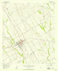
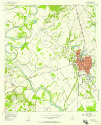 1957 Marlin1958 Print · USGSFalls County during the mid-fifties is captured here as a bustling rail crossroads where the Missouri Pacific and Texas and New Orleans meet. Local researchers can trace old community landmarks from the Courthouse and Booker T Washington High Sch to rural stops like Rocky Hill.3 unique versions available
 - 1957 Map of Robinson, 1958 Print
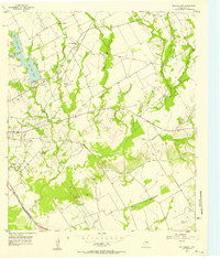
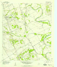 1957 Robinson1958 Print · USGSNear the banks of the Brazos River in the late 1950s, this area shows a landscape defined by rail and river. Genealogists can trace family roots through numerous sites like Rosenthal High Sch, Mt Zion Ch, and Mt Olive Cem.4 unique versions available
End of results
Showing maps 1-11 of 11
Top cities of Falls County
Frequently asked questions
- What are the different types of historical maps available for Falls County?
- What is the oldest map of Falls County?
- Where can I purchase historical maps of Falls County for my home or office?
- Where can I download high-res historical maps of Falls County?
- Are there historical topographic maps available for Falls County?
- Is there historical aerial imagery available for Falls County?
- Where are historical maps of Falls County sourced from?