1950s Maps of Fannin County, Texas
Explore 8 historic maps of Fannin County from the 1950s. These maps offer a rare glimpse into what life looked like during the 1950s — showing old roads, neighborhoods, homes, and landmarks that have changed or disappeared over time.
Whether you're researching your family's past, planning a metal detecting trip, or studying how Fannin County's landscape evolved across the 1950s, these high-resolution maps are a powerful tool for exploring the history of this region.
- Focus on a specific era: All maps on this page are from the 1950s, giving you a focused view of this time period.
- See what’s changed: Compare century-old streets, trails, and buildings to today's modern landscape using overlays and satellite layers.
- Research with precision: Use these maps for genealogy, historical research, land use analysis, or educational projects.
- View, download, or print: Maps are fully viewable online in high resolution, and can be downloaded or printed for your own records.
Start exploring Fannin County's history through authentic maps from the 1950s. This is your window into the past.
Fannin County, TX maps
(8)- 1953 Map of Texarkana, 1964 Print
 1953 Texarkana1964 Print · USGSThe Texas-Arkansas borderlands are captured here in the mid-fifties, during a decade of massive military and hydraulic engineering projects. Genealogists and researchers can locate family landmarks like Old Boston Cem, Siloam Ch, and the vast Red River Arsenal.4 unique versions available
 - 1954 Map of Sherman, 1964 Print
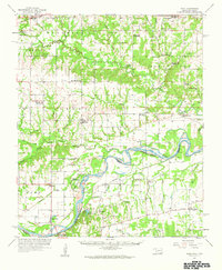
 1954 Sherman1964 Print · USGSThe Red River valley and North Texas plains are captured here in the mid-fifties, showing the region as new reservoirs like Lake Texoma and Lavon Reservoir reshaped the land. Genealogists can trace family roots through specific local landmarks like Courtney P O, Pilot Grove Sch, and New Hope Ch.2 unique versions available
 - 1956 Map of Texarkana
 1956 Texarkana1956 Print · USGSThe Ark-La-Tex borderlands come alive in the mid-fifties, showing the transition from a rail-dependent rural economy to a post-war industrial landscape. Researchers can trace the massive Red River Ordnance Depot and find towns like Talco, Bogata, and Naples.
 - 1957 Map of Wade, 1959 Print
 1957 Wade1959 Print · USGSThe Red River frontier comes to life in the late fifties as it winds between Oklahoma and Texas. Genealogists can trace family roots at Old Philadelphia Cem, find the INDIAN BOUNDARY, or locate vanished schoolhouses like Beames Sch (Abandoned).
 - 1958 Map of Durant, 1959 Print
 1958 Durant1959 Print · USGSSouthern Oklahoma and the Texas borderlands meet along the Red River in the late fifties, showcasing a landscape of rail-fed towns and river crossings. Genealogists can trace family roots through several landmarks like Rose Hill Cem, Lee Chapel, and the historic Old Indian Boundary Line.3 unique versions available
 - 1958 Map of Bonham, 1959 Print
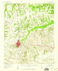 1958 Bonham1959 Print · USGSFannin County in the late fifties shows a landscape of established rail towns and quiet river bluffs along the Oklahoma border. Genealogists can trace family roots through dozens of local sites like Odd Fellows Cem, Sowells Bluff, and St Mark Ch.
 - 1958 Map of Whitesright, 1959 Print
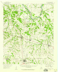 1958 Whitesright1959 Print · USGSGrayson and Fannin Counties are captured here in the late fifties, showcasing a landscape of thriving rail-towns and quiet farming communities. Researchers can locate dozens of country burial sites and schools, from Sunnyside Cem to the Bethel Sch.2 unique versions available
 - 1958 Map of Sherman, 1959 Print
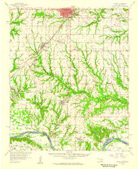
 1958 Sherman1959 Print · USGSNorth Texas and Southern Oklahoma were undergoing significant development in the late fifties as the Red River Valley transit networks matured. Researchers can trace historic family-named locations such as Saddler Bend, the grounds of Perrin AFB, and early shoreline developments at Lake Texoma.
End of results
Showing maps 1-8 of 8
Top cities of Fannin County
- Bonham historical maps
- Leonard historical maps
- Honey Grove historical maps
- Savoy historical maps
- Trenton historical maps
- Ladonia historical maps
See more
Frequently asked questions
- What are the different types of historical maps available for Fannin County?
- What is the oldest map of Fannin County?
- Where can I purchase historical maps of Fannin County for my home or office?
- Where can I download high-res historical maps of Fannin County?
- Are there historical topographic maps available for Fannin County?
- Is there historical aerial imagery available for Fannin County?
- Where are historical maps of Fannin County sourced from?