Old Maps of Fannin County, Texas for Academic Research
Study the evolution of Fannin County with 187 high-resolution historic maps. Whether you're teaching, researching, or modeling changes in land use, these maps provide essential visual documentation of urban, environmental, and geographic change.
- Analyze long-term change: Track patterns in development, transportation, and natural features.
- Ideal for environmental or urban studies: Support academic projects with primary historical map data.
- Use in the classroom or lab: Educators and researchers rely on these maps to bring historical context to life.
These maps are a powerful tool for teaching, research, and visualizing how Fannin County has changed over the decades.
Fannin County, TX maps
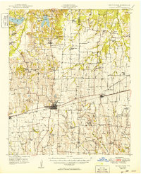
(187)- 1903 Map of Paris
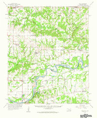
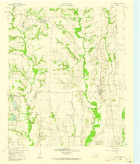
 1903 Paris1903 Print · USGSThe Red River borderlands of the Indian Territory and Texas are shown here at the start of the century. Genealogists and researchers can trace early settlements and social hubs like Grant, Oberlin, and the Camp Ground along the winding banks of the Red River.
 - 1947 Map of Honey Grove, 1966 Print
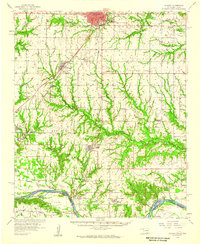
 1947 Honey Grove1966 Print · USGSNortheast Texas at the close of the 1940s reveals a landscape of thriving rural school districts and rail-side commerce. Genealogists can trace family roots through numerous sites like McCraw Chapel, Oakwood Cem, and Michigan Prairie School.2 unique versions available
 - 1948 Map of Direct, 1968 Print
 1948 Direct1968 Print · USGSThe Red River valley at the close of the 1940s reveals a landscape of isolated farming communities and local schools spanning the Oklahoma-Texas border. Genealogists and historians can trace the foundations of New Oberlin or locate remote landmarks like Iron Stob School and Arch Chapel Cem.
 - 1949 Map of Direct
 1949 Direct1949 Print · USGSThe Oklahoma and Texas borderlands along the Red River are captured here in the late 1940s. Local historians can trace the vanished Oberlin Ferry and old country schools like Crowder Springs School or visit family sites at Forest Grove Cem and Monkstown.2 unique versions available
 - 1949 Map of Honey Grove
 1949 Honey Grove1949 Print · USGSIn the late 1940s, the rural corridor between Honey Grove and Petty thrived as a network of rail-side towns and country schoolhouses. Genealogists can trace family landmarks like Spoonamore Hill, the Michigan Prairie School, and Oakwood Cem.
 - 1953 Map of Texarkana, 1964 Print
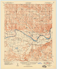
 1953 Texarkana1964 Print · USGSThe Texas-Arkansas borderlands are captured here in the mid-fifties, during a decade of massive military and hydraulic engineering projects. Genealogists and researchers can locate family landmarks like Old Boston Cem, Siloam Ch, and the vast Red River Arsenal.4 unique versions available
 - 1954 Map of Sherman, 1964 Print
 1954 Sherman1964 Print · USGSThe Red River valley and North Texas plains are captured here in the mid-fifties, showing the region as new reservoirs like Lake Texoma and Lavon Reservoir reshaped the land. Genealogists can trace family roots through specific local landmarks like Courtney P O, Pilot Grove Sch, and New Hope Ch.2 unique versions available
 - 1956 Map of Texarkana
 1956 Texarkana1956 Print · USGSThe Ark-La-Tex borderlands come alive in the mid-fifties, showing the transition from a rail-dependent rural economy to a post-war industrial landscape. Researchers can trace the massive Red River Ordnance Depot and find towns like Talco, Bogata, and Naples.
 - 1957 Map of Wade, 1959 Print
 1957 Wade1959 Print · USGSThe Red River frontier comes to life in the late fifties as it winds between Oklahoma and Texas. Genealogists can trace family roots at Old Philadelphia Cem, find the INDIAN BOUNDARY, or locate vanished schoolhouses like Beames Sch (Abandoned).
 - 1958 Map of Durant, 1959 Print
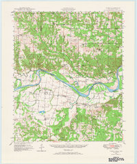
 1958 Durant1959 Print · USGSSouthern Oklahoma and the Texas borderlands meet along the Red River in the late fifties, showcasing a landscape of rail-fed towns and river crossings. Genealogists can trace family roots through several landmarks like Rose Hill Cem, Lee Chapel, and the historic Old Indian Boundary Line.3 unique versions available
 - 1958 Map of Bonham, 1959 Print
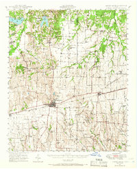
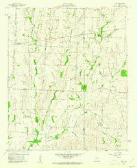
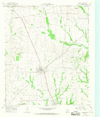
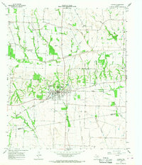
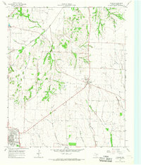
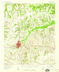 1958 Bonham1959 Print · USGSFannin County in the late fifties shows a landscape of established rail towns and quiet river bluffs along the Oklahoma border. Genealogists can trace family roots through dozens of local sites like Odd Fellows Cem, Sowells Bluff, and St Mark Ch.
 - 1958 Map of Whitesright, 1959 Print
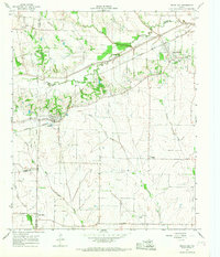
 1958 Whitesright1959 Print · USGSGrayson and Fannin Counties are captured here in the late fifties, showcasing a landscape of thriving rail-towns and quiet farming communities. Researchers can locate dozens of country burial sites and schools, from Sunnyside Cem to the Bethel Sch.2 unique versions available
 - 1958 Map of Sherman, 1959 Print
 1958 Sherman1959 Print · USGSNorth Texas and Southern Oklahoma were undergoing significant development in the late fifties as the Red River Valley transit networks matured. Researchers can trace historic family-named locations such as Saddler Bend, the grounds of Perrin AFB, and early shoreline developments at Lake Texoma.
 - 1960 Map of Blue Ridge, 1962 Print
 1960 Blue Ridge1962 Print · USGSCollin County agricultural life at the start of the sixties reveals a network of small crossroads communities and family-named landmarks. Trace the locations of historic sites like Westminster Cem, Snow Hill Ch, and the old Quarries.2 unique versions available
 - 1960 Map of Pike, 1962 Print
 1960 Pike1962 Print · USGSNortheast Texas at the start of the sixties is a landscape of quiet rural junctions and family homesteads where Collin, Fannin, and Hunt counties meet. Genealogists can trace early settler footprints at Indian Creek Cem, Fuller Cem, and the small settlement of Frognot.2 unique versions available
 - 1964 Map of Trenton, 1967 Print
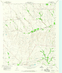
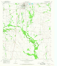
 1964 Trenton1967 Print · USGSThe rural landscape of Fannin County in the mid-1960s is defined by its small rail-side settlements and winding creek beds. Genealogists and historians can trace family roots through landmarks like Burns Cem, Blanton Chapel, and the communities of Orangeville and Nobility.
 - 1964 Map of Pilot Grove, 1967 Print
 1964 Pilot Grove1967 Print · USGSNear the intersection of Grayson, Fannin, and Collin counties in the mid-1960s, this rural landscape centers on the Pilot Grove Creek forks. Researchers can trace family history through local landmarks like Worden Cem, Starks Chapel Ch, and the settlement of Pilot Grove.2 unique versions available
 - 1964 Map of Celeste, 1968 Print
 1964 Celeste1968 Print · USGSHunt County at the height of the mid-century rail era reveals a landscape shaped by competing locomotives and winding river forks. Genealogists and local historians can trace family ties through Nicholson Cemetery and Kingston Cemetery or locate old settlements like Hogeye and Lester.
 - 1964 Map of Ladonia, 1968 Print
 1964 Ladonia1968 Print · USGSNortheastern Texas crossroads near the Fannin and Hunt County line are captured here in the mid-sixties. Researchers can trace the Atchison Topeka and Santa Fe rail line and locate rural landmarks like Bug Tussle, Clark High Sch, and the Odd Fellows Cem.
 - 1964 Map of Pecan Gap, 1968 Print
 1964 Pecan Gap1968 Print · USGSPecan Gap and its surrounding farm country appear here in the mid-sixties, dominated by the winding Sulphur River. Genealogists can trace family sites via the many local burial grounds like Bledsoe Cem or the oddly named Jot Em Down community.2 unique versions available
 - 1964 Map of Gober, 1968 Print
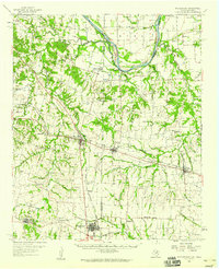
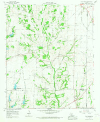
 1964 Gober1968 Print · USGSNortheast Texas farmland along the Fannin and Hunt county line is captured here in the mid-sixties as rural life centered on small rail-side towns and river bottoms. Researchers can trace family sites at Rehobeth Cem, the community of Gober, and the Atchison Topeka and Santa Fe rail line.
 - 1964 Map of Leonard, 1968 Print
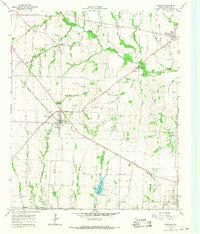
 1964 Leonard1968 Print · USGSFannin County agriculture and rail transit intersect in the mid-1960s, centered on the growing hub of Leonard and the M-K-T RR. Researchers can locate family landmarks like Grove Hill Ch, Whiterock Cem, and the old Valley Creek Community Center.
 - 1965 Map of Wolfe City, 1968 Print
 1965 Wolfe City1968 Print · USGSWolfe City and the rural reaches of Hunt County are captured here in the mid-1960s during a period of agricultural stability. Genealogists and local historians can trace family roots at Westbrook Cem, visit the old Wesley Ch, or follow the Sante Fe and Atchison Topeka rail line.
 - 1980 Map of Telephone, 1981 Print
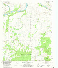
 1980 Telephone1981 Print · USGSThe Red River borderlands of Fannin County were captured in the early eighties as a landscape of small farms and protected grasslands. Local researchers can trace family landmarks like Old Elwood Cem, the rural Telephone community, and the Sam Rayburn Sch.
 - 1980 Map of Monkstown, 1981 Print
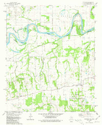
 1980 Monkstown1981 Print · USGSThe Red River border between Texas and Oklahoma comes into focus during the early 1980s, showcasing the agricultural rhythm of Fannin County. Researchers can trace rural cemetery sites like Arch Chapel Cem and Bigsby Cem or locate the sprawling Caddo National Grassland.
Showing maps 1-25 of 187
Top cities of Fannin County
- Bonham historical maps
- Leonard historical maps
- Honey Grove historical maps
- Savoy historical maps
- Trenton historical maps
- Ladonia historical maps
See more
Frequently asked questions
- What are the different types of historical maps available for Fannin County?
- What is the oldest map of Fannin County?
- Where can I purchase historical maps of Fannin County for my home or office?
- Where can I download high-res historical maps of Fannin County?
- Are there historical topographic maps available for Fannin County?
- Is there historical aerial imagery available for Fannin County?
- Where are historical maps of Fannin County sourced from?