1950s Maps of Foard County, Texas
Explore 8 historic maps of Foard County from the 1950s. These maps offer a rare glimpse into what life looked like during the 1950s — showing old roads, neighborhoods, homes, and landmarks that have changed or disappeared over time.
Whether you're researching your family's past, planning a metal detecting trip, or studying how Foard County's landscape evolved across the 1950s, these high-resolution maps are a powerful tool for exploring the history of this region.
- Focus on a specific era: All maps on this page are from the 1950s, giving you a focused view of this time period.
- See what’s changed: Compare century-old streets, trails, and buildings to today's modern landscape using overlays and satellite layers.
- Research with precision: Use these maps for genealogy, historical research, land use analysis, or educational projects.
- View, download, or print: Maps are fully viewable online in high resolution, and can be downloaded or printed for your own records.
Start exploring Foard County's history through authentic maps from the 1950s. This is your window into the past.
Foard County, TX maps
(8)- 1954 Map of Lubbock, 1958 Print
 1954 Lubbock1958 Print · USGSThe High Plains and Caprock region of West Texas come alive in the mid-1950s, showing a landscape defined by oil discovery and the Brazos River headwaters. Genealogists and historians can trace rail-connected towns like Roaring Springs, find the Pleasant Valley church, or locate family-named landmarks such as Soldier Mound.4 unique versions available
 - 1954 Map of Plainview, 1966 Print
 1954 Plainview1966 Print · USGSThe Texas Panhandle and the rugged Caprock Escarpment appear in detail as the region's agricultural and rail networks reached their mid-century peak. Trace family roots and old land patterns through the canyons and plains near Plainview, Palo Duro State Park, and Childress.3 unique versions available
 - 1954 Map of Wichita Falls, 1966 Print
 1954 Wichita Falls1966 Print · USGSNorth Texas in the mid-fifties is captured here as a landscape of expanding oil fields and vital rail corridors. Genealogists and historians can trace family roots through rural landmarks like Bacon Chapel and the rail-side growth of Seymour and Archer City.3 unique versions available
 - 1955 Map of Lawton, 1958 Print
 1955 Lawton1958 Print · USGSSouthwestern Oklahoma and North Texas are shown here in the mid-fifties, dominated by the Wichita Mountains and the vital Red River watershed. Genealogists and historians can trace the foundations of Lawton alongside rural landmarks like Rainy Mountain Church and Pleasant Hill School.5 unique versions available
 - 1958 Map of Wichita Falls
 1958 Wichita Falls1958 Print · USGSNorth Texas during the late fifties reveals a landscape defined by the booming petroleum industry and established rail hubs. Researchers can trace the development of Wichita Falls and discover rural landmarks like Barton's Chapel or the Hull-Silk Oil Field.
 - 1958 Map of Plainview
 1958 Plainview1958 Print · USGSThe High Plains and Caprock Escarpment meet in the late fifties, showcasing the ranching and rail networks of the Texas Panhandle. Trace family roots and vanished stops along the Panhandle and Santa Fe railroad through Plainview, Silverton, and Matador.
 - 1958 Map of Vernon, 1959 Print
 1958 Vernon1959 Print · USGSWilbarger County is captured in the late fifties as the local economy balanced ranching traditions with growing civic infrastructure. Researchers can locate family landmarks such as Lockett High Sch, the Santa Rosa Roundup Rodeo Grounds, and Pleasant Home Ch.2 unique versions available
 - 1958 Map of Medicine Mound, 1959 Print
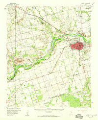
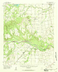 1958 Medicine Mound1959 Print · USGSHardeman and Foard Counties are shown here in the late fifties, defined by the winding Pease River and the iconic Medicine Mounds. Researchers can locate the Pease River Battlefield, the town of Margaret, and the Panhandle and Santa Fe rail line.
End of results
Showing maps 1-8 of 8
Top cities of Foard County
Frequently asked questions
- What are the different types of historical maps available for Foard County?
- What is the oldest map of Foard County?
- Where can I purchase historical maps of Foard County for my home or office?
- Where can I download high-res historical maps of Foard County?
- Are there historical topographic maps available for Foard County?
- Is there historical aerial imagery available for Foard County?
- Where are historical maps of Foard County sourced from?