1960s Maps of Foard County, Texas
Explore 16 historic maps of Foard County from the 1960s. These maps offer a rare glimpse into what life looked like during the 1960s — showing old roads, neighborhoods, homes, and landmarks that have changed or disappeared over time.
Whether you're researching your family's past, planning a metal detecting trip, or studying how Foard County's landscape evolved across the 1960s, these high-resolution maps are a powerful tool for exploring the history of this region.
- Focus on a specific era: All maps on this page are from the 1960s, giving you a focused view of this time period.
- See what’s changed: Compare century-old streets, trails, and buildings to today's modern landscape using overlays and satellite layers.
- Research with precision: Use these maps for genealogy, historical research, land use analysis, or educational projects.
- View, download, or print: Maps are fully viewable online in high resolution, and can be downloaded or printed for your own records.
Start exploring Foard County's history through authentic maps from the 1960s. This is your window into the past.
Foard County, TX maps
(16)- 1960 Map of Teacup Mountain, 1962 Print
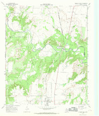
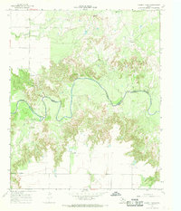
 1960 Teacup Mountain1962 Print · USGSFoard and Hardeman counties are captured in the early sixties as they were shaped by the winding Pease River. Local historians can trace family landmarks and geographic features like Teacup Mountain, Sugarloaf Mountain, and the remote Oil Well site.
 - 1966 Map of Truscott North, 1968 Print
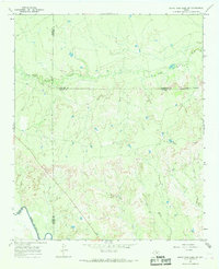
 1966 Truscott North1968 Print · USGSKnox County and Foard County meet in this mid-1960s survey of the rolling breaks along the North Wichita River. Researchers can trace the Atchison Topeka and Santa Fe rail line and locate landmarks like the settlement of Truscott and the Gaging Sta.2 unique versions available
 - 1966 Map of Santa Rosa Lake SW, 1968 Print
 1966 Santa Rosa Lake SW1968 Print · USGSThe Rolling Plains of North Texas are captured here in the mid-1960s, showing the rugged ranch lands where Baylor, Foard, and Wilbarger counties intersect. Genealogists and researchers can trace local landmarks like Corral and Waggoner or follow the paths of South Beaver Creek and the North Wichita River.
 - 1966 Map of Soap Creek, 1968 Print
 1966 Soap Creek1968 Print · USGSThe confluence of the Wichita River forks in North Texas is captured here in the mid-1960s. Family historians and researchers can locate the Henson Cem and trace the Arledge Ranch Landing Strip among the drainage of Soap Creek.
 - 1966 Map of Colwell Creek, 1969 Print
 1966 Colwell Creek1969 Print · USGSNorth Texas ranch land and the winding breaks of the North Wichita River are captured here in the mid-1960s. Genealogists and local historians can trace family landmarks like Massingill, K Camp, and the uniquely named Ignorant Ridge.
 - 1966 Map of Halsell Ranch, 1969 Print
 1966 Halsell Ranch1969 Print · USGSRanching life on the Foard and Knox County line is documented here during the mid-sixties, centered on the North Wichita River. Researchers can locate specific pastoral landmarks like the Halsell Ranch, West Camp, and the essential Deadman Windmill.
 - 1966 Map of Big Four Ranch, 1969 Print
 1966 Big Four Ranch1969 Print · USGSSpanning the tri-county border of Foard, King, and Knox in the mid-sixties, this map reveals the ranching heart of North Texas. Genealogists and researchers can trace family-named landmarks like Masterson and the historic Big Four Ranch among the forks of the Wichita River.
 - 1966 Map of Crowell, 1969 Print
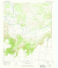
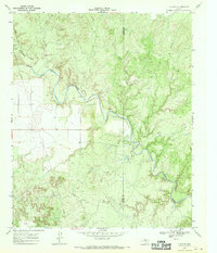
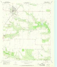 1966 Crowell1969 Print · USGSCrowell and the rolling plains of Foard County are captured in the mid-sixties, showing a landscape defined by the Atchison Topeka and Santa Fe rail line. Researchers can trace the legacy of the area through Crowell Cem, the County Airfield, and the winding Beaver Creek.
 - 1966 Map of Thalia, 1969 Print
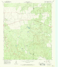
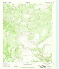
 1966 Thalia1969 Print · USGSThe rural plains of Foard County are captured here in the mid-1960s, centered on the settlement of Thalia. Genealogists and researchers can trace local water sources like Three-Quarter Tank and the winding course of Middle Beaver Creek.
 - 1966 Map of Santa Rosa Lake NW, 1969 Print
 1966 Santa Rosa Lake NW1969 Print · USGSTexas ranching and agricultural life near the Wilbarger and Foard county line are preserved here in the mid-sixties. Local researchers can locate working landmarks like Iron Pens, Slay Camp, and the winding banks of Beaver Creek.
 - 1966 Map of Lowrance Mountain, 1969 Print
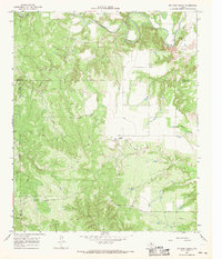
 1966 Lowrance Mountain1969 Print · USGSThe Wichita River breaks of King County are captured here in the mid-1960s, showing a remote ranching landscape transitioning into the oil and gas era. Researchers can locate the Lowrance Ranch and its landing strip or trace water sources like Pouring Spring and Marys Lake.2 unique versions available
 - 1967 Map of Triangle Ranch, 1969 Print
 1967 Triangle Ranch1969 Print · USGSCottle County ranching country is captured here in the late sixties, showing the vast livestock operations that define this Texas region. Researchers can locate the Ogden (Site), trace family landmarks like Marys Peak, and find remote outposts like Polk Hole Windmill.2 unique versions available
 - 1967 Map of Baker, 1969 Print
 1967 Baker1969 Print · USGSCottle County ranch lands are documented here in the late sixties, where the railroad and river define the northern frontier. Researchers can trace the Quanah Acme and Pacific rail line past Baker or locate the Y L Ranch and its Landing Strip among the creek prongs.2 unique versions available
 - 1968 Map of Y Ranch, 1970 Print
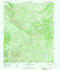
 1968 Y Ranch1970 Print · USGSCottle and Foard counties are captured in the late sixties as the ranching economy and oil industry shaped the West Texas landscape. Researchers can locate the Y Ranch headquarters, the local Landing Strip, and several Oil Wells along the North Wichita River.2 unique versions available
 - 1968 Map of Boiling Spring, 1970 Print
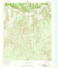
 1968 Boiling Spring1970 Print · USGSFoard County ranch lands were defined by their water sources in the late 1960s. Researchers can trace the rugged drainage patterns of Blue Hole Creek and Good Creek as they feed into the North Wichita River near Boiling Spring.2 unique versions available
 - 1968 Map of Foard City, 1970 Print
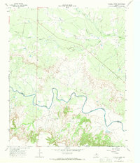
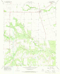
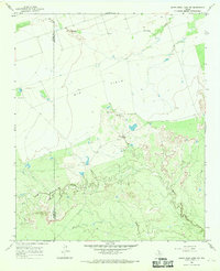
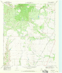 1968 Foard City1970 Print · USGSFoard County during the late sixties reveals a landscape of cattle ranching and rail transport on the North Texas plains. Genealogists and historians can trace the Atchison Topeka and Santa Fe line as it passes Foard City and crosses Beaver Creek.
End of results
Showing maps 1-16 of 16
Top cities of Foard County
Frequently asked questions
- What are the different types of historical maps available for Foard County?
- What is the oldest map of Foard County?
- Where can I purchase historical maps of Foard County for my home or office?
- Where can I download high-res historical maps of Foard County?
- Are there historical topographic maps available for Foard County?
- Is there historical aerial imagery available for Foard County?
- Where are historical maps of Foard County sourced from?