1970s Maps of Frio County, Texas
Explore 10 historic maps of Frio County from the 1970s. These maps offer a rare glimpse into what life looked like during the 1970s — showing old roads, neighborhoods, homes, and landmarks that have changed or disappeared over time.
Whether you're researching your family's past, planning a metal detecting trip, or studying how Frio County's landscape evolved across the 1970s, these high-resolution maps are a powerful tool for exploring the history of this region.
- Focus on a specific era: All maps on this page are from the 1970s, giving you a focused view of this time period.
- See what’s changed: Compare century-old streets, trails, and buildings to today's modern landscape using overlays and satellite layers.
- Research with precision: Use these maps for genealogy, historical research, land use analysis, or educational projects.
- View, download, or print: Maps are fully viewable online in high resolution, and can be downloaded or printed for your own records.
Start exploring Frio County's history through authentic maps from the 1970s. This is your window into the past.
Frio County, TX maps
(10)- 1974 Map of Johnnie Little Hill, 1977 Print
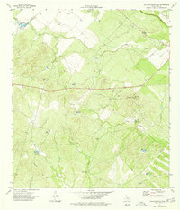
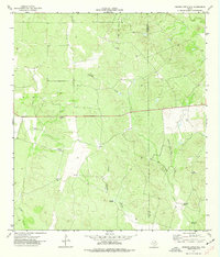 1974 Johnnie Little Hill1977 Print · USGSZavala and Frio counties are shown here in the mid-1970s, capturing a remote landscape of South Texas ranching and water management. Researchers can trace the cattle-country infrastructure of the day through features like Johnnie Little Hill, Three Leg Windmills, and Fight and Holler Creek.
 - 1974 Map of Snake Creek, 1977 Print
 1974 Snake Creek1977 Print · USGSSouth Texas ranch and oil country come into focus during the mid-seventies where four counties meet. Trace the industrial landscape of the Big Wells Oil Field and old fence lines near the settlement of Baggett and Snake Creek.
 - 1974 Map of Dilley, 1977 Print
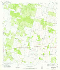
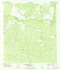
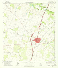 1974 Dilley1977 Print · USGSThe South Texas brush country around Dilley appears here in the mid-1970s, shaped by the confluence of the Frio and Leona rivers. Researchers can trace local landmarks like the Winter Garden Rodeo Ground, the Missouri Pacific rail line, and the Hugo Cem.
 - 1974 Map of Divot, 1977 Print
 1974 Divot1977 Print · USGSSouth Texas ranching and oil operations are captured in detail here during the mid-1970s. Local researchers can trace the drainage of the Leona River and locate family-named landmarks like Parks Corner Windmill and the settlement of Divot.
 - 1974 Map of Holcomb Reservoir, 1977 Print
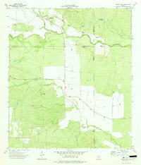
 1974 Holcomb Reservoir1977 Print · USGSFrio County ranchlands were defined by vital water infrastructure and prominent hill elevations during the mid-1970s. Trace the distribution of livestock water sources like Garden Tank and English Hills Tank or the high ground at Pilot Knob.
 - 1974 Map of Gross Tank, 1977 Print
 1974 Gross Tank1977 Print · USGSThe ranchlands of Zavala and Uvalde counties are captured here in the mid-1970s at a time of increasing energy exploration. Researchers can trace the water-dependent settlement patterns along the Frio River, identified by numerous Gas Wells and remote landmarks like Gross Tank.
 - 1974 Map of Woodward NE, 1977 Print
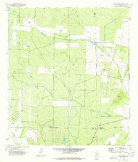
 1974 Woodward NE1977 Print · USGSSouth Texas brush country during the mid-seventies reveals a landscape of isolated ranching outposts and winding creek beds. Genealogists and local historians can locate St Mary Chapel, Covey Chapel Cem, and the shifting waters of Dry Cibolo Creek.
 - 1974 Map of Frio Town, 1977 Print
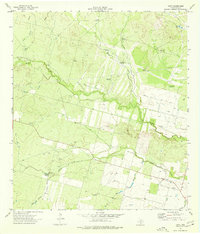
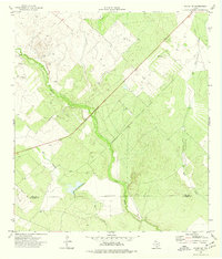
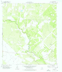 1974 Frio Town1977 Print · USGSThe ranchlands of South Texas are captured in the mid-1970s as the historic settlement of Frio Town remained a vital landmark. Researchers can trace the riverfront at Rock House Ranch, find the Frio Town Cem, and locate numerous family and industrial sites like TJ Windmill.
 - 1974 Map of West Ranch, 1977 Print
 1974 West Ranch1977 Print · USGSThe ranchlands along the Zavala and Frio county line come into focus during the mid-seventies as the regional energy economy expanded. Genealogists and land researchers can trace family-named water sources like Roberts Windmill and remote sites near West Ranch.
 - 1974 Map of Dilley NE, 1977 Print
 1974 Dilley NE1977 Print · USGSSouth Texas ranch and brush country comes into focus in the mid-seventies as the Frio River winds through the borderlands. Researchers can trace land use near the Frio and La Salle county line or locate old operations like the Gravel Pits.
End of results
Showing maps 1-10 of 10
Top cities of Frio County
Frequently asked questions
- What are the different types of historical maps available for Frio County?
- What is the oldest map of Frio County?
- Where can I purchase historical maps of Frio County for my home or office?
- Where can I download high-res historical maps of Frio County?
- Are there historical topographic maps available for Frio County?
- Is there historical aerial imagery available for Frio County?
- Where are historical maps of Frio County sourced from?