1940s Maps of Hitchcock, Texas
Explore 5 historic maps of Hitchcock from the 1940s. These maps offer a rare glimpse into what life looked like during the 1940s — showing old roads, neighborhoods, homes, and landmarks that have changed or disappeared over time.
Whether you're researching your family's past, planning a metal detecting trip, or studying how Hitchcock's landscape evolved across the 1940s, these high-resolution maps are a powerful tool for exploring the history of this region.
- Focus on a specific era: All maps on this page are from the 1940s, giving you a focused view of this time period.
- See what’s changed: Compare century-old streets, trails, and buildings to today's modern landscape using overlays and satellite layers.
- Research with precision: Use these maps for genealogy, historical research, land use analysis, or educational projects.
- View, download, or print: Maps are fully viewable online in high resolution, and can be downloaded or printed for your own records.
Start exploring Hitchcock's history through authentic maps from the 1940s. This is your window into the past.
Hitchcock, TX maps
(5)- 1943 Map of Virginia Point
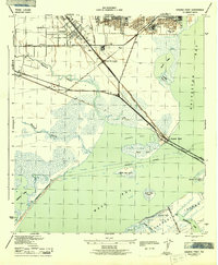 1943 Virginia Point1943 Print · USGSGalveston County was a hive of industrial and maritime activity during the war years. Local historians can trace the critical rail lines of the Santa Fe and the strategic connection at Virginia Point leading toward Galveston Island.2 unique versions available
 - 1943 Map of Lake Como
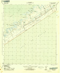 1943 Lake Como1943 Print · USGSGalveston Island's central reaches are shown here in the early 1940s, highlighting the natural drainage systems and coastal topography. Trace the early road network from Eight Mile Road to Thirteen Mile Road while exploring landmarks like the Lookout Tower and Lake Como.2 unique versions available
 - 1943 Map of Mustang Bayou
 1943 Mustang Bayou1943 Print · USGSThe coastal prairie south of Houston during the 1940s reveals a landscape of tidal bayous and early irrigation. Genealogists and historians can trace the Missouri Pacific Road and find landmarks like the German Cem and Briscoe Canal.2 unique versions available
 - 1943 Map of Carancahua Lake, 1952 Print
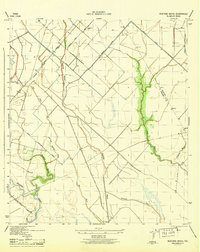
 1943 Carancahua Lake1952 Print · USGSThe Galveston and Brazoria county line met in the tidal marshes and open waters of the West Bay during the 1940s. Researchers can trace the early path of the Intracoastal Waterway and locate landmarks like Rattlesnake Mound and Boathouse Ruins.
 - 1943 Map of Dickinson, 1953 Print
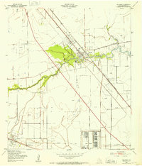 1943 Dickinson1953 Print · USGSCoastal Galveston County comes alive during the war years, showing a landscape defined by military sites and the winding Dickinson Bayou. You can trace family roots at Arcadia, locate the Santa Fe Consolidated Sch, and explore the layout of Camp Wallace.
End of results
Showing maps 1-5 of 5
Top cities near Hitchcock
- League City historical maps
- Galveston historical maps
- Texas City historical maps
- Friendswood historical maps
- Alvin historical maps
- Dickinson historical maps
See more
Top neighborhoods of Hitchcock
Frequently asked questions
- What are the different types of historical maps available for Hitchcock?
- What is the oldest map of Hitchcock?
- Where can I purchase historical maps of Hitchcock for my home or office?
- Where can I download high-res historical maps of Hitchcock?
- Are there historical topographic maps available for Hitchcock?
- Is there historical aerial imagery available for Hitchcock?
- Where are historical maps of Hitchcock sourced from?