1960s Maps of Post, Texas
Explore 2 historic maps of Post from the 1960s. These maps offer a rare glimpse into what life looked like during the 1960s — showing old roads, neighborhoods, homes, and landmarks that have changed or disappeared over time.
Whether you're researching your family's past, planning a metal detecting trip, or studying how Post's landscape evolved across the 1960s, these high-resolution maps are a powerful tool for exploring the history of this region.
- Focus on a specific era: All maps on this page are from the 1960s, giving you a focused view of this time period.
- See what’s changed: Compare century-old streets, trails, and buildings to today's modern landscape using overlays and satellite layers.
- Research with precision: Use these maps for genealogy, historical research, land use analysis, or educational projects.
- View, download, or print: Maps are fully viewable online in high resolution, and can be downloaded or printed for your own records.
Start exploring Post's history through authentic maps from the 1960s. This is your window into the past.
Post, TX maps
(2)- 1969 Map of Post East, 1972 Print
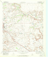 1969 Post East1972 Print · USGSIn the late 1960s, Post, Texas, sat at the intersection of the High Plains and the developing West Texas oil patches. Researchers can trace the Atchison Topeka and Santa Fe rail line, the Terrace Cem, and family landmarks like the Cross H Ranch.
 - 1969 Map of Post West, 1972 Print
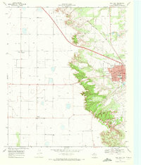 1969 Post West1972 Print · USGSThe Garza County landscape in the late sixties reveals the industrial and civic heart of Post as it sits along the Atchison Topeka and Santa Fe line. Researchers can locate family landmarks like Garza Memorial Hospital or trace the early development of Close City.
End of results
Showing maps 1-2 of 2
Top cities near Post
Frequently asked questions
- What are the different types of historical maps available for Post?
- What is the oldest map of Post?
- Where can I purchase historical maps of Post for my home or office?
- Where can I download high-res historical maps of Post?
- Are there historical topographic maps available for Post?
- Is there historical aerial imagery available for Post?
- Where are historical maps of Post sourced from?